The purpose of this page is to provide a review of the Irish High Crosses of what is now County Westmeath. It begins, however, with an overview of human habitation in what is now County Westmeath up to about 1200. That date is generally accepted as the end of the High Cross period. Following that survey each of the High Crosses will be introduced with background, where available, on the site and a description and photographs of the crosses. The crosses discussed include Bealin, Clonfad, Kilmacnevan, Fore and Foyran.
Mesolithic Westmeath: 8000 to 4000 BCE
The mesolithic culture in Ireland was characterized by hunter-gatherers who moved from place to place, establishing temporary, seasonal camps. Surviving artifacts include lithic scatters of small blades and points and later larger stone tools and weapons. Cultural remains of the early population have not been found in the midlands. (O Carroll-Mitchell)
One example of a mesolithic site in County Westmeath is found at Corralanna. A 2009 report published in the Proceedings of the Royal Irish Academy: Archaeology, Culture, History, Literature reports that following peat harvesting in 1999 a site was discovered that contained lithic artifacts. These were mostly of chert and included two axes and other stone tools. (Warren, p. 1)
Neolithic Westmeath: (4000–2400 BC)
Neolithic inhabitants of Ireland were engaged in farming, pastoral care of domesticated animals, pottery making and weaving. More substantial housing and stone monuments characterize this period. Megalithic monuments included cairns, passage tombs, wedge tombs and portal tombs or dolmen. Grave goods from this period include pottery, arrowheads, beads, pendants, axes and more.
As with the Mesolithic period, finds from this period in County Westmeath and the midlands in general are scarce. One find from a bog in Westmeath was a basket. It was made of “long slivers of wood bound with straw.” The bowl is pictured to the right above. “Wooden and bone implements were used for fencing in crops, tilling, hoeing and harvesting. Bags, buckets and other containers were made from available materials. Pottery was made from clay and decorated.” (Women in History, text and photo)
The archaeological site around the Hill of Uisneach offers a bridge between the Neolithic and the medieval period, embracing the Bronze Age and Iron Age. Roseanne Schot, in a paper entitled “Uisneach Midi a melon Erenn: a prehistoric ‘cult’ center and ‘royal site’ in Co. Westmeath” describes the variety of sites present in the area. There are “over twenty monuments, including a possible megalithic tomb, barrows, enclosures, two holy wells and an embanked roadway. These monuments range in date from the Neolithic or early Bronze Age to the medieval period, and indicate that the hill has been the focus of a prolonged sequence of human activity spanning some five millennia.” (Schot, p. 39)
The Hill of Uisneach is located near the geographical center of Ireland and in Irish mythology it is the sacred center of the island. The possible megalithic tomb, known as ‘St. Patrick’s Bed,’ ties the site to sacred use in early prehistory. Schot goes on to state “the presence of other funerary monuments, including two extant ring-barrows and a series of possible ‘ring-ditches’ . . . suggest that Uisneach maintained a role as a place of sacral importance from an early period in prehistory.” (Schot, p. 45) The illustration on the following page shows the variety and geographical scope of the Uisneach site. (Schot, p. 43, map)
Bronze Age Westmeath: 2400-500 BCE
Metallurgy, and the beginning of the Bronze Age, arrived in Ireland with the Beaker people who had a distinctive style of pottery. Tin and copper were mined and alloyed to produce bronze. Artifacts include swords, axes, daggers, hatchets, awls, drinking utensils and more. The metallurgists also fashioned objects of gold, which was plentiful in Ireland. This was also a time when stone circles and fulachtai fia were constructed. Fulachtai fia were troughs used for cooking in water heated by rocks transferred from a fire to the pit.
One method of burial during the Bronze Age was single-grave cist burials. The Westmeath Examiner reported the discovery of a cist burial during work on the new N52 road near Turin, northwest of Mullingar. Senior archaeologist Mary Deevy described the find. “Inside the cist was a crouched inhumation – the skeleton of an adult who would have been placed inside the cist in a fetal position. Beside the skeleton was a small, bowl-shaped pottery vessel. The bowl was empty and may have originally contained a food offering,” (Westmeath Examiner)
Another Bronze Age discovery in County Westmeath was found in 2005. It is a major timber-built road at Mayne bog, Coole. It was at least 675m long and was carbon 14 dated to 1200-820 BCE. There has been controversy over the destruction of portions of the roadway. Below is a photo of a portion of the road taken in 2015. (3000 year old bog roadway and photo)
Iron Age Westmeath: 500 BCE to 400 CE
The Iron Age is typically interpreted as the time when the Celts began to arrive in Ireland. It is possible, however, that working in iron arrived in Ireland as much as 300 years earlier, before the arrival of the Celts. One way or the other, a new kind of metallurgy, work with iron, began.
Archaeological evidence for the Iron age in County Westmeath is scarce. However, the complex of sites around Uisneach suggests “a prolonged sequence of human activity spanning some five millennia.” (Schot, p. 39) One of the sites excavated, the Penannular Enclosure seems to date to the late Iron age, “between the third and fifth centuries.” (Schot, p. 54)
The pollen record for this period indicates a decrease in woodland by as much as 50% island wide. This resulted, in part, from the use of firewood and charcoal in smithing and associated activities. During this time one source for iron ore, used in iron manufacturing, was bog ore. One example of this from County Westmeath can be found in a medieval context at Clonfad and suggests the extraction of bog ore may have been widespread. (OCarroll-Mitchell paper)
During this period promontory forts and ring forts appear. A list of hill forts in County Westmeath offers only one site, Bigwood contour fort. (List of Hillforts)
Early Medieval Westmeath: 400 to 1100 CE
The Early Medieval period is marked by the continued use of iron, the arrival of the Christian faith in Ireland, and the beginning of the historical period of Irish history.
There is archaeological evidence for the medieval period in County Westmeath. Much of it dates to the 6th to 9th or 6th to 12th centuries. One such find comes from Clonfad. Excavation revealed an early ecclesiastical site. It appears to have thrived from the 6th to the mid 9th century CE. There was evidence for the manufacture of hand bells and related to this, a large amount of metallurgical residues. Artifacts were numerous and included bone combs, leather work, metal, stone, ceramic and bone tools and a musical instrument. There was evidence of a workshop with smithing hearths, iron working features, cereal drying kilns, and wells. About the mid 9th century the site appears to have gone into decline. (Archaeological Excavation report) Additional information on the ecclesiastical history of Westmeath will appear below.
Another archaeological feature that dates to the Early Medieval is a Crannog at Newtownlow. Cormac Bourke reported that this crannog was “continuously occupied between the 6th/7th and 12th centuries.” Metalwork and glasswork as well as imported goods were found. (Bourke)
Political History
As we enter the early Medieval period, we begin to find historical documents that help us to understand what the peoples of Ireland were doing. The Annals of Ulster offer us a picture of the area that includes the present County Westmeath in the 5th and early 6th centuries. In the 5th and 6th centuries, the area was contested by the Laigin and what would become the Southern Ui Neill. The the battle of Druim Derg, in 516, gave the Southern Ui Neill control of Mide.
U516.1 The battle of Druim Derg against Failge. Fiacha was victor. Thereafter the plain of Mide was taken away from the Laigin. (Annals of Ulster)
Following the conquest of Mide a possible “royal seat” of the Cenel Fiachach, one branch of the Southern Ui Neill, was established at Uisneach. Tirechan, writing in the late 7th century reported a meeting of St. Patrick and a son of Fiacha, the victor at Druim Derg, at Uisneach. (Schot, p. 39) However, according to Eoin O’Flynn in a paper entitled “The organization and operation of Ui Neill kingship in the Irish midlands: Clann Cholmain c. 550-916”, “the existence of a kingship based at or named after the site [Uisneach] appears unlikely. But there is clear evidence for the significance and sensitivity of Uisnech and it seems that it was a place where political authority in Mide could be claimed or challenged.” (O’Flynn, p. 154)
O’Flynn goes on to state that “in reality we still know virtually nothing about the ‘real’ sixth-century individuals. In short, this period in Clann Cholmain’s history remains quite obscure.” (O’Flynn, p. 137) During the 6th and 7th centuries early leaders of Clann Cholmain had rivals not only among the Laigin, but also the Sil nAedo Slaine. The Sil nAedo Slaine were another branch of the Southern Ui Neill and were kings of Brega. It was not until after the death of Cinaed mac Irgaliag in 728 that Clann Cholmain came to dominate the the leadership of Mide and Brega.
From the late 7th century into the 8th century the history of Clann Cholmain become clearer. During the early 8th century Clann Cholmain consolidated their position in the midlands. They adopted the epithet ‘Midi’ and installed allies in the kingship of Mide. (O’Flynn, p. 181) O’Flynn notes that “with the death of Fallomon in 766 we have the first reliable reference to the kingship of Mide, an institution which in this and other early appearances represented a local deputyship. We have also seen further evidence for the hierarchical, layered system of kingship in operation among the Ui Neill of the midlands and Clann Cholmain specifically.” (O’Flynn, p. 195)
The 9th century saw Clann Cholmain seeking to extend its influence. O’Flynn suggests that “Alliance with and control of the major churches must also be considered in the context of the pursuit of power by Clann Cholmain, and indeed by Cenel nEogain.” (O’Flynn, p. 206) During this time there was competition between Clann Cholmain and Munster for wider control. This began to undermine the stability of the relationship between the Connachta and Clann Cholmain.
The Vikings added a new dimension to the political dynamics of Mide in the 9th century. At times, as in 848, Mael Sechnaill (Mael Sechnaill mac Maele Ruanaid or Mael Sechnaill I), king at Tara and of Clann Cholmain, defeated the Vikings in a battle at Forach. In addition to conflict with the Vikings, Mael Sechnaill attacked Munster. In 854 and 856 he hosted into Munster. In 856 he was also engaged in warfare with the Vikings. Of the events of this time, O’Flynn writes, “Mael Sechnaill was projecting his power far beyond the boundaries of his own midland territories and using military forces of diverse origins to make his claim to island-wide political dominance.” (O’Flynn, p. 219) Mael Sechnaill died in 862.
The high cross at Kinnitty in County Offaly has the following inscription. “A prayer for King Maelsechnaill son of Maelrunaid. A prayer for the king of Ireland.” and “A prayer for Colman who made the cross for the king of Ireland. A prayer for the king of Ireland.” The high cross at Durrow also seems to have an inscription that refers to Mael Sechnaill. These reflect “Mael Sechnaill’s successes in bringing Ulster, Munster and Osraige to submission were unprecedented.” (O’Flynn, p. 221)
Mael Sechnaill I was succeeded by his son Flann Sinna. Flann ruled through the end of the 9th and the beginning of the 10th centuries. He died in 916. O’Flynn summarized his rule.
“Though Flann continued to pursue the ambitious policies of his father Máel Sechnaill, his reign is in fact characterised by considerable fluctuations in his real power, notwithstanding Máel Mura's rhetoric and the claim of the Cross of the Scriptures inscription. The links between Clann Cholmáin and the major midland churches remained important and the physical evidence at Clonmacnoise which dates from Flann's reign specifically attests to the particular significance of that relationship. Aggression towards Munster continued to characterise Clann Cholmáin policy but Flann's grip over Osraige does not appear to have been as assured as that of his father. Crucially, we see periods of real deterioration in the relationship between Clann Cholmáin and their longtime allies in Connacht. Also, Flann faced considerable and enduring internal opposition from his sons, the type of opposition which had previously been confined to the years immediately following the death of a king. The ability of several Cenél nEógain kings to make symbolic appearances in the midlands during Flann's reign might ordinarily be dismissed as representing the vagaries of campaigning but Níall Glúndub's influence in restoring peace between Flann and his sons suggests a real weakness in Clann Cholmáin's position. The dynasty's ambitions remained great and it certainly was able to realise them on occasion. But equally it seems that broader shifts in the political landscape were beginning to tell against Clann Cholmáin.” (O’Flynn, pp. 238-9)
In the late 10th century Mael Sechnaill mac Domnaill (Mael Sechnaill II) was High King with his power base in Mide. At various times he was in conflict with Brian Boru, king of Munster. In 996/7, when Brian Boru gained control of Leinster, Mael Sechnaill agreed that Brian would have control of Leth Moga, the souther half of Ireland. Following renewed conflict, in 1002, Mael Sechnaill ceded his title as High King to Brian. Following Brian’s death at Clontarf, Mael Sechnaill regained his title as High King. After Mael Sechnaill’s death, Clann Cholmain provided no further High Kings.
In the middle of the 11th century an alliance between Diarmait mac Mael na nBo of Leinster and Niall mac Eochada of the Ulaid put pressure on Clann Cholmain in Brega and Mide. During this century, Mide was in conflict with other provincial kings and was partitioned at times and collapsed as a coherent kingdom.
In the 12th century, following the Norman invasion in 1172, Henry II of England gave the prominence of Mide to Hugh de Lacy, who became the Lord of Meath.
Ecclesiastical History
The Christian faith arrived in Ireland at an uncertain time in the 4th or 5th century. Ireland boasts a number of pre-Patrician saints in the south as well as the mission of Palladius, who operated in the south as well, sometime in the early 5th century. After about 430, St. Patrick arrived with what turned out to be a successful missionary effort. St. Patrick was active in establishing churches, some of which were in what is now County Westmeath. According to the “List of Monastic houses in County Westmeath,” Patrick was involved in establishing churches that became monasteries at Druim-corcortri, Lakan and Usnagh.
It is also reported that St. Patrick wanted to establish a church at the ancient sacred site of Uisneach. There are two different stories told about what occurred there. Tirechan tells us that Patrick met two sons of Niall, Fiachu and Endae.
“In Uisnech of Meath he stayed next to the Rock of Coithrige, but some of his foreign companions were killed in his presence by a son of Fiachu son of Niall. He cursed him, saying. ‘There will be no king of your seed, but you shall serve the seed of your brothers.’” (Charles-Edwards p. 28)
The other story appears in the Tripartite Life.
“He [Patrick] came again from Tara as far as Uisnech. He attempted to found a church there. Two sons of Niall, that is, Fiachu and Endae, resisted him. Patrick said to them that it would be their descendants who wold inhabit that foundation if he were to receive a welcome from them. They refused him and seized his hand. ‘A curse,’ said Patrick, ‘on the stones of UIisnech,’ said Sechnall [Patrick’s companion]. ‘Let it be so,’ said Patrick. No good use has been made of them from that day onwards: they are not even made into washing stones.” (Charles-Edwards, p. 29)
Whatever else occurred, Patrick did not found a church at Uisnech.
In the late 6th century, St. Aedh mac Bricc was active in establishing at least three monasteries, at Killare, Rahugh and Rathaspick. At Killare, St. Aedh accomplished what Patrick did not. He established a church at Uisnech. The Rev. Professor Stokes described St. Aedh (Hugh) as the apostle of Westmeath and a contemporary of St. Columba. (Stokes, p. 325ff) The dates for St. Aedh’s monasteries in County Westmeath center around 590. Some time before that, in the 550’s St. Columba had founded a monastery at Durrow. St. Aedh’s monastery at Rahugh was not far away. In County Westmeath, Columba was credited with the establishment of Clonfad and Teernacreeve. (List of Monastic Houses)
The latest monastery established in the early Christian period in Westmeath was Tyfarnham, established in about 880. (List of Monastic Houses)
As elsewhere in Ireland, the monasteries were the centers of religious life in Ireland, the Abbots having more authority than the bishops in most cases. This situation largely continued until the Synod of Rath Breasail in 1111. At that time a regular diocesan and parish system was established in Ireland to match that in the rest of the Roman church.
The list of early monasteries in County Westmeath below contains the names of 37 monasteries. As with most other Irish counties, only a few of these monasteries had high crosses that have survived in some form to the present. These are: Bealin, which may have been located originally at Clonmacnois, Clonfad, Foyran and Fore.
Athlone, early site
Ballymore, early site, c. 700?
Church Island, Lough Owel, early site, by St. Lomman
Clonfad, early site, 6th century by St. Colmcille
Clonfad, early site, 6th century by St. Finnian of Clonard
Cluain-moescnae, early site
Conry, early site, 7th century?
Druim-corcortri, early site, 5th century by St. Patrick
Drumraney, early site, before 588, hermitage
Dysart Tola, early site, pre 738 by St. Tola
Faughalstown, early site, patronized by St. Diarmaid 6th century
Fore, early site, c. 630 by St. Fechin
Foyran, early site, patronized/founded by St. Edan
Hare Island, early site, pre 542, by St. Ciaran of Clonmacnois
Inchbofin, early site, mid-5th century, St. Rioch
Inchmore ,early site, 5th century?, Liberius (Lioban)
Kilbeggan, early site, 6th/7th century by St. Beccan
Kilbixy, early site, monks and nuns, St. Bicsech the Virgin?
Kilcumreragh, early site, St. Fiachra?
Kilkenny West Hospital, early site, c. mid-6th century by St. Canice
Killalea, early site
Killare early site, St. Aedh mac Bricc
Killucan, early site, St. Lucan (Lucain)
Killulagh, early site, 5th century, St. Lonan (time of Patrick)
Kiltoom, early site, 5th century
Lackan, early site, founded 5th century, St. Patrick?
Lynn, early site
Rahugh, early site, pre 589 by St. Aedh mac Bricc
Rathaspick, early site, pre 589 by St. Aedh mac Bricc
Taughmon, early site, pre 635-6 by St. Fintan Munna
Teaghbaithen, early site
Teernacreeve, early site, 6th century? by St. Colmcille
Temple Macateer, early site, by St. Ciaran mac an tsaoir?
Tuaim-inbhir, early site, pre 916
Turbotstown, early site, pre 809, by St. Fechin?
Tyfarnham, early site, pre 880
Usnagh, early site, 5th century, by St. Patrick
Resources Consulted
3000 year old bog roadway, http://irisharchaeology.ie/2015/08/the-destruction-of-a-3000-year-old-bog-roadway-in-co-westmeath/
Annals of Ulster, https://celt.ucc.ie//published/T100001A/index.html
Archaeological Excavation report, https://repository.dri.ie/catalog/cj82zp112
Bourke, Cormac, https://www.academia.edu/14515455/The_Excavation_of_an_Early_Medieval_Crannog_at_Newtownlow_County_Westmeath
Charles-Edwards, T.M., Early Christian Ireland, Cambridge University Press, 2000.
List of Hillforts, https://en.wikipedia.org/wiki/List_of_hillforts_in_Ireland#County_Westmeath
List of Monastic Houses, Westmeath, https://en.wikipedia.org/wiki/List_of_monastic_houses_in_County_Westmeath
O’Carroll-Mitchell paper, https://www.tii.ie/technical-services/archaeology/resources/OCarroll-Mitchell-paper.pdf
Schot, Roseanne, https://www.academia.edu/12163521/Uisneach_Midi_a_medón_Érenn_a_prehistoric_cult_centre_and_royal_site_in_Co._Westmeath
Stokes, Rev. Professor, “St. Hugh of Rahue: His Church, His Life, and His Times,” The Journal of the royal Society of Antiquaries of Ireland, Vol. 26, 1849.
Warren, Graeme, Aimée Little, Michael Stanley, Conor McDermott and Emmett O’Keeffe, “A late Mesolithic lithic scatter from Corralanna, Co. Westmeath, and its place in the Mesolithic landscape of the Irish Midlands.” Proceedings of the Royal Irish Academy: Archaeology, Culture, History, Literature, Vol. 109C (2009), pp. 1-35 (35 pages)
Westmeath Examiner, https://www.westmeathexaminer.ie/2019/08/16/the-discovery-of-a-4000-year-old-early-bronze-age-cist-burial-containing-the-crouched-skeleton/
Women in History, text and photo. http://womeninhistory.scoilnet.ie/content/unit1/neolithic.html
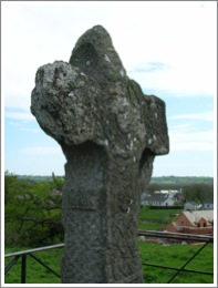
Bealin or Twyford Cross
Getting There: This cross led me on a merry-go-round chase. It lies in County Westmeath a few kilometers northeast of the city of Athlone. Part of the difficulty in finding it is that it is not signposted. I knew the approximate area it was in and, as it turned out, I drove a complete ring around the site before stopping at a small convenience store to ask for directions. The first attendant I asked about the cross had never heard of it. She was in the process of getting the attention of another employee for me when one of the customers said that he lived just up the road from the cross. He was headed home after he finished his shopping and invited me to follow him, which I did. He turned on a road that led into the center of the circle I had made earlier. Before long he slowed his car and pointed up a side road to the left then waved goodbye.
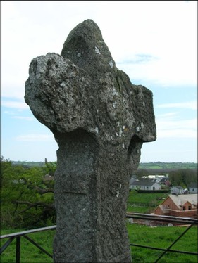
I turned left and drove up the road till it ended at a closed gate. There was no sign of a cross or sign for a cross. At the time all I knew, other than the general location was what Peter Harbison had written in his monumental study of the Irish High Crosses. “The cross now standing on top of a hill in the former Twyford demesne, close to a lane leading northwards from Bealin Post Office, is almost certainly not in its original location.” (Harbison, 1992, p. 26) So I knew the cross was on top of a small hill. There was in fact a small but steep hill just to the west of the road about where the gate was. I climbed over the gate to see if there was access to the top of the hill from that side. There was not, but, I could see the top of the cross from there. So I climbed back over the gate, turned the car around and drove slowly back down the road, looking for some sort of access. Not far down the road I stopped and asked a neighbor, who happened to be outside, how to reach the cross. He pointed to an area just north of his house where I could park. He told me to take the stile over the fence and I would find a pathway that would take me to the cross. And it did.
The views from the cross were lovely and the cross, weatherbeaten and damaged still has a variety of clearly visible carving.
The Cross
The cross and its origins are a mystery. As Harbison noted, its present location was not its original site. Where it originated is unknown. Most of the Irish High Crosses are associated with a monastic site, and Francoise Henry drew the conclusion that the Bealin Cross was originally from Clonmacnois or at least produced by the Clonmacnois workshop. She based this on two factors. The first derives from an inscription on the cross that reads “Pray for Tuthgall who caused this cross to be made.” She associates this name with an Abbot of Clonmacnois “who seems to have governed the monastery of Clonmacnois from 798 to 810 or 811.” (Henry, 1965, pp. 143-144) Peter Harbison and others question this identification pointing out that the name is more correctly read as Tuathgail. Their conclusion being that the inscription may not refer to the Abbot of Clonmacnois.
At stake in this discussion is not only the provenance of the cross but the dating of this and other Irish High Crosses. If Tuthgall (Tuthgail) was the Abbot of Clonmacnoise and was behind the carving of the Bealin Cross, a very firm late 8th or early 9th century date for the cross could be confirmed. Based on sylistic similarities this would allow the dating of other crosses as well.
The photo above was taken in 2008 and shows not only the cross, but some of the lovely landscape that surrounds it. The photos below show the east and west faces of the cross and were taken by Henry Crawford. (Crawford, 1927)

Stylistic similarities between the Bealin Cross and some of the carvings that are clearly from Clonmacnois is the second point of Henry’s argument for a Clonmacnois origin for the Bealin Cross. Others, including Carol Hicks, identify a “distinctive regional group” that includes “five pieces, the shaft known as the Banagher pillar in the National Museum, Dublin, the ringed cross at Bealin, county Westmeath, and three shafts at the monastic site of Clonmacnois, county Offaly.” These five pieces have “artistic features which characterise the group [and] can be compared closely to certain elements in the Book of Kells.” (Hicks, p. 5) So the Bealin cross, regardless of its origins, is related to other carvings that are part of a Clonmacnois workshop. The Book of Kells is also dated to the late 8th or early 9th century.
As an aside, Henry proposed the possibility that the Bealin Cross may be the cross marked with the letter R on Blaymires’ 17th century view of Clonmacnois. There is no definite evidence to support this. (Harbison, 1992, p. 27)
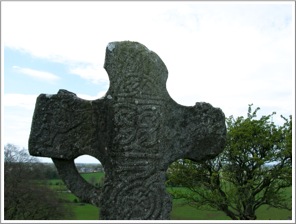
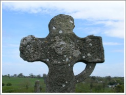
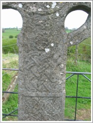
The East Face
In the center of the head of the cross is a square panel with two-strand interlace. Above this is a three-pointed knot of interlace. The south arm has a lion facing to the left. The image on the arm is not particularly clear to me in any of my photos. The north arm has been badly damaged so that no carving is visible there. (Harbison, 1992, p. 27)
Harbison identifies another lion at the bottom of the shaft. It has a projecting tongue and raised tail. It is also facing left. This makes me wonder if there might have been a lion on the north arm of the cross as well.(Harbison, 1992, p. 27)
The photos below show the east face of the cross, the right photo being focused on the head of the cross.
The main section of the shaft has an elaborate zoomorphic design. The drawing and description below are from Henry Crawford.
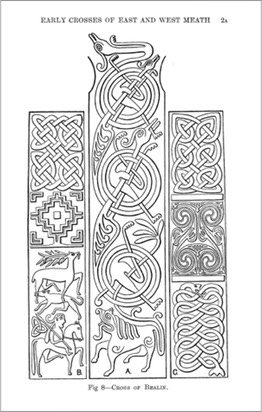
“The whole shaft from the base to the level of the arms is covered with one zoomorphic design in which three elongated animals are placed one above another; they have bird-like heads and show one foreleg and two hind legs. The neck and foreleg are in two cases interlaced with the coiled body of the animal next above. As the uppermost one has no coil to pass through, it is completed by having the neck and leg bent back into a horizontal positon.
“The tails of two of these animals are omitted, and this is the more remarkable as it throws the interlacing wrong, but this is not the only instance in which the interlacing of zoomorphic designs is incorrect. The base of the panel is filled by an animal of a different kind (as thickset as the others are attenuated), the tail of which passes through the coil formed by the body of the animal above it.” (Crawford, 1927, p. 2)
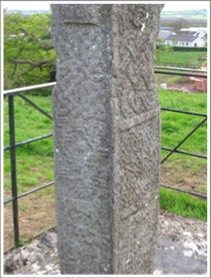
The South Side
The south side is dominated by interlace patterns. These can be found on the end of the arm, the underside of the ring and the upper panel of the shaft. The center of the shaft is a square panel that Harbison describes as follows: “A lyre-like design, consisting of a pelta-shaped C-spiral rising upwards to two outward-coiling spirals.” The lowest design on the south face is that of an animal. The head is above and a fish-like tail below. (Harbison, 1992, p. 27) The designs on the south side of the cross are well illustrated above by Crawford.
The two photos below and the photo to the right show the south side of the cross.
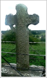
The West Face
The central design on the west head is a series of circles. At the center is a round knot of interlace with a raised circle around it. Moving outward is a circle of interlace with another raised circle surrounding it. “The south arm has loose interlace enclosing a round knot of interlace, similar to that between the birds’ necks on the shaft. The decoration of the north arm is similar, though more worn, while the ornamentation of the top of the cross has been completely obliterated.” (Harbison, 1992, p. 27) Crawford adds that “there were originally five flat bosses covered with knotwork and occupying the usual positions. Crawford 1927, p. 2) The “usual positions” would mean there was a boss in the center of the head, on each arm, the upper extension of the shaft and below the center boss about where the ring joins the shaft.
Moving down the shaft and enclosing the lower boss is a "six-cord plait formed by the bodies of two animals of the serpent or sea-horse type.” The center panel is a square of circular knot-work. (Crawford, 1927, p. 3)

The lowest panel on the west face contains the inscription discussed briefly above. “Pray for Tuthgall who caused this cross to be made.”
The three photos, above left, to the left and right below show the west face of the cross.
North Side
The north side of the cross has three panels. An illustration can be seen above with the illustrations of the east face and the south side. The upper panel is filled with “broken plait-work: this is an eight-cord plait in which two horizontal and two vertical breaks have been made.” (Crawford, 1927, p. 3)
The center panel has a Greek cross “formed of two bands of step pattern, and having the angles filled by L-shaped pieces.” (Crawford, 1927, p. 3)
Crawford describes the lowest panel on the north side as follows. “The lowest panel contains a scene of considerable interest. At the base is a mounted hunter armed with a spear: he is the only human figure on the monument. Above is a stag at bay, and a large dog which greatly resembles the old Irish hound. As some space was vacant over the hindquarters of the horse, the sculptor has filled it in by carving a triquetra.” (Crawford, 1927, p. 3)
The two crosses (left and right) show the north side of the cross.
Francoise Henry discusses what she considers to be the Christian content of the hunt scene. She points out that the scene probably has pagan origins. The stag and horse being “the two Celtic animal-shaped divinities which appear most frequently in Gallo-Roman carvings.” (Henry, 1965, p. 155) In another work, Henry explains the possible Christian content of the scene. “In Christian times, the stag ’thirsting for running waters’ (Psalm 42) became a symbol of the soul thirsting for God. It is represented with that meaning in innumberable monuments . . . The stag-hunt then, can become a figure of Christ pursuing a soul. That it actually did is suggested by the fact that on the Bealin cross the hunter is accompanied by the threefold knot, a symbol of the Trinity.” (Henry, 1964, p. 52)
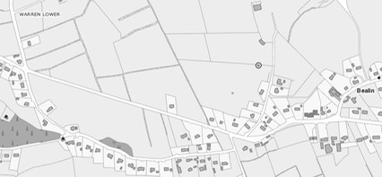
Getting There: See Road Atlas page 33 2 D. From the R390 take an unnamed road south just over 1km east of the N55. This road enters the map to the right in the upper left corner. The site can be reached via a path that starts between houses on the side road.
The map is cropped from the Historic Environment Viewer.
Resources Consulted
Crawford, Henry, “The Early Crosses of East and West Meath”, The Journal of the Royal Society of Antiquaries of Ireland, Sixth Series, Vol. 17, No. 1 (Jun. 30, 1927), pp. 1-6.
Harbison, Peter; The High Crosses of Ireland: An Iconographical and Photographic Survey, Dr. Rudolf Habelt GMBH, Bonn, 1992. Volume 1: Text, Volume 2: Photographic Survey; Volume 3: Illustrations of Comparative Iconography.
Henry, Franciose, Irish Art in the Early Christian Period (to 800 A.D.), Methuen and Co. LTD, London, 1965.
Henry, Francoise; Irish High Crosses, Three Candles LTD., Dublin, 1964.
Hicks, Carola, “A Clonmacnois Workshop in Stone”, The Journal of the Royal Society of Antiquaries of Ireland, Vol. 110 (1980), pp. 5-35.
Clonfad/Rattin
The Site
Precise information concerning the Clonfad monastery is complicated by the fact there were two sites called Clonfad, both in County Westmeath, and at a distance of about 6.2 miles (10km) apart. One is found along the N52, between Tyrellspass and Dalystown. The second Clonfad is located off the R446 about mid-way between Kinnegad and Milltownpass. An archaeological dig at the site along the N52 resulted in evidence of the production of hand bells. (Stevens, 2006, p. 9) This Clonfad that was founded in the 6th century, probably by St. Finnian of Clonard. Finnian was succeeded by St. Senach, bishop of Clonard and Clonfad and libra of Clonfad, abbot or priest. (Stevens, Settlement and Community in the Fir Tulach Kingdom and Cogan p. 555-556)) This latter Clonfad was known as Cluain-foda-fine or Cluain-foda-Librain meaning “St. Libran’s Long Lawn or Meadow.” (Cogan p. 555)
The Clonfad along the R446 is the subject of this entry. It is there we find two remnants of high crosses. A monastery was established here in the 6th century by Bishop Etchen (d. 578) St. Etchen was of the royal house of Leinster. It is reported that it was Etchen who ordained St. Columba. (Cogan p. 553-554)
It is mentioned in literature in the mid 8th century and again in 799. The Annals of the Four Masters described it as being burnt and desecrated in 887. (Stevens, 2006, p. 8) The site was apparently abandoned in 891, following another catastrophic fire.
The Crosses

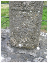
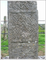
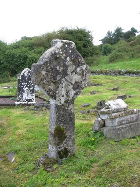
Clonfad/Rattin 1: Shaft fragment of a small cross. It stands about 20 inches high by 10 inches wide by 6 inches thick. The shaft has a panel of interlace on the south, roll mouldings on the corners and holes on the north side. (Harbison, 1992, p. 46)
Clonfad/Rattin 2: The head and part of the shaft of a cross stands 58 inches high and 40 inches across the arms. The north arm has been reattached and the south arm indicates that this was a ringed cross. A roll moulding trims the edges with a narrower rib inside. The cap on the cross is irregular and the top may not have belonged to the original cross. The base that the cross stands on measures 37 by 33 inches at ground level. (Harbison, 1992, p. 46)
Getting There: See Road Atlas page 34 2 H. Located north of the R446 about mid-way between Kinnegad and Milltownpass.
The map is cropped from the Historic Environment Viewer.
Sources Consulted
Cogan, Anthony, The Ecclesiastical History of the Diocese of Meath: Ancient and Modern, Vol. 3., pp.553-555.
Harbison, Peter, The High Crosses of Ireland: An Iconographical and Photographic Survey, 3 vols. Dublin, Royal Irish Academy. Bonn, Dr. Rudolff Habelt GMBH, 1992.
Historic Environment Viewer: http://webgis.archaeology.ie/historicenvironment/
Stevens, Paul, “A Monastic Enclosure Site at Clonfad, Co. Westmeath," Archaeology Ireland, Vol. 20, No. 2 (Summer, 2006), pp. 8-11.
Stevens, Paul, “Clonfad — An Industrious Monastery”, Settlement and Community in the Fir Tulach Kingdom.
Fore Cross
The Site and Saint
Around the year 630 St. Fechin founded a monastery along the river Glore. During the life of St. Fechin it grew to some 3000 monks, drawn from numerous countries. It is said that the place was known as Baile Leabhair or the “Town of Books.”
St. Fechin was born in County Sligo of a chieftains family but early on showed a preference for the ascetic and anchorite life. St. Fechin had founded other churches and monasteries including the Abbey of Ballysadare in County Sligo, Termon Fechin near Drogheda in County Meath and several on islets around the Galway coast. Fechin’s monastery prohibited the entrance of women, and his rule was severe. Fechin died of the plague in 665.
Across the years, from 771 to 1169 the monastery was burnt about a dozen times. At least part of these depredations were committed by Vikings from nearby Ballania. (Seven Wonders of Fore)
Later a Benedictine Abbey was founded in the valley below the original St. Fechin monastery. Most of the buildings date to the early 13th century.
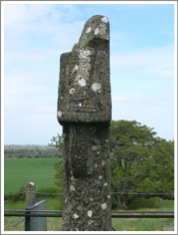
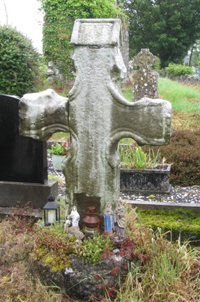
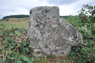
The Cross
A cross-head stands near St. Fechin’s church. It is ringed and has no mouldings or decoration. At present it stands 4 feet high and 39 inches across the arms. The shaft fragment is 14 inches wide.
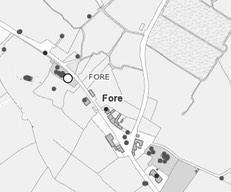
Getting There: See Road Atlas page 26 4 H. Located on the west side of the town of Fore. The cross is located on the south side of the road.
The map is cropped from the Historic Environment Viewer.
Resources Consulted
G.B., “Fore Abbey, County westmeath”, The Dublin Penny Journal, vol. 3, No. 152 (May 30, 1835), pp. 380-381.
Harbison, P. 1992 The high crosses of Ireland: an iconographical and photographic survey, 3 vols. Dublin. Royal Irish Academy. Bonn. Dr. Rudolf Habelt GMBH.
Historic Environment Viewer: http://webgis.archaeology.ie/historicenvironment/
Voices From the Dawn: http://www.voicesfromthedawn.com/seven-wonders-of-fore/
Stokes, G. T., “St. Fechin of Fore and His Monastery”, The journal of the Royal Society of Antiquaries of Ireland, Fifth Series, Vol. 2, No 1 (Apr., 1892), pp. 1-12.
Foyran Cross
In 1928 Henry Crawford listed two crosses at Foyran. He described both as Wayside Crosses rather than High Crosses.
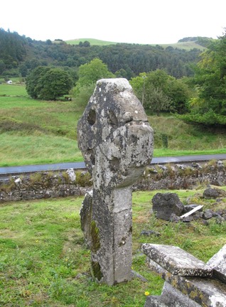
Cross 1: Crawford described this cross as “A plain cross 3ft. 6in. in height with an unpierced ring. It is unbroken and stands on the west fence of the road one eighth mile N.W. of Foyran church.”
Cross 2: The cross-head he described as “The head of a cross 2ft. 2in. in breadth with a solid ring about 1ft. 4in. in diameter. A rude crucifixion is incised on the front. The stone is built into the west fence of the road almost opposite to the church.” (Crawford, p. 57)
Cross 1 seems to have vanished while the cross-head is mounted on the top of a field bank about 250m West of the Foyran Church.
The photo to the left was provided by James Dempsey (Megalithicireland.com).
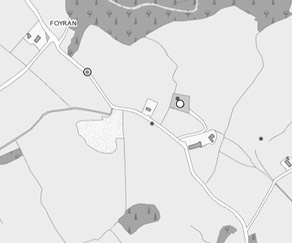
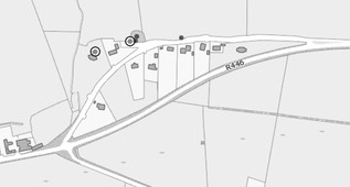
Getting There: See Road Atlas page 26 4 G. Located east of the R394 about 2km east of Castletown. See the circle on the road near Foyran.
The map is cropped from the Historic Environment Viewer.
Sources Consulted
Crawford, Henry S., “List of the Wayside Crosses near Fore, County Westmeath,” The Journal of the Royal Society of Antiquaries of Ireland, Sixth Series, Vol. 18, No. 1 (Jun. 30, 1928), pp. 57-62.
O’Brien, Caimin, http://webgis.archaeology.ie/historicenvironment/. County Westmeath, High Cross, Foyran.
Kilmacnevan Cross
The Site: There is an Early Christian monastic site here with the ruins of the Kilmacnevan Church and a graveyard.
The Cross: in the south quadrant of the graveyard there is the head of a ringed cross and nearby is a circular stone with a mortise hole in the center that appears to have been the base of this cross. A date of the 10th or 11th century has been suggested.
No photo is presently available.
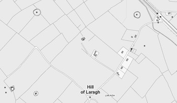
Getting There: See Road Atlas page 34 1 F. The site is reached from the R393. Take an unnamed road to the southwest about 2km southeast of Ballynacarrigy. Cross the Royal Canal and follow the map to the right. The site is indicated by the white circle in the lower left corner of the map.
The map is cropped from the Historic Environment Viewer.
Sources Consulted:
http://webgis.archaeology.ie/historicenvironment/. County Westmeath, High Cro