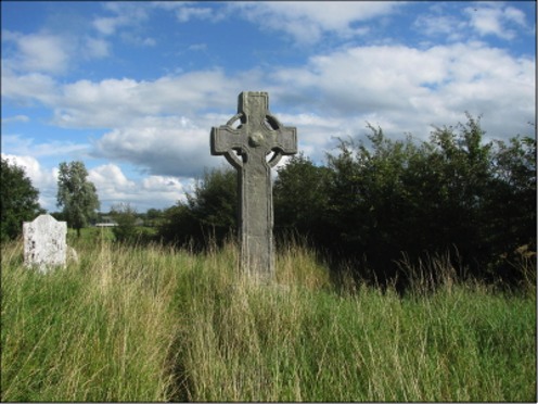
This page highlights the crosses at Castlekieran in County Meath. It includes an Introduction to the Site, a description of each of the Crosses located there and other features on the site, including a cross base, a cross slab, and an Ogham stone I've also included a personal story about Getting There. The photo above of the South Cross shows that the interior of the enclosure was heavily overgrown. (photo 2011)
Introduction to the Site
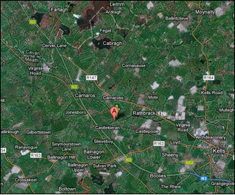
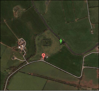
The Castlekieran monastic site is located in County Meath just west of Kells as illustrated by the two Google maps below. In the map on the left the approximate location of the site is indicated by the "A" marker. The town of Kells is in the lower right corner. On the right the rectangular enclosure of the monastery can be seen just above the "A" marker. It is located in a field just behind a two-story yellow farm house. The entrance is through the farm yard gate. The site is not visible from the road. Megalithicireland.com offers directions to the site. Megalithomania.com provides GPS coordinates.
Castlekieran was known in ancient times as Bealaigh-duin or “the Road or Pass of the Fort.” In early Medieval times there were a number of raths or cashels in the area. A monastery was founded here by Saint Ciaran which became know as Diseart Chiarain-Bealaigh-duin, “Ciaran’s desert at the Road of the Fort.” (Cogan, pp. 124-5) There are several Irish saints with the name of Ciaran (Kieran). St. Kieran of Disert-Kieran, Co. Meath, was referred to by the Irish Annals as "Kieran the Devout". He wrote a "Life of St. Patrick." (New Advent, Kieran) The monastery he founded is mentioned several times in the Annals of the Four Masters.
770: Ciaran, the Pious, of Bealach-duin, died on the 14th of June.
855: Siadhal of Chiarainl (died)
868: Comsudh, Abbot of Disert-Chiarain, of Bealach-duin, scribe and bishop, died.
949: Godfrey, son of Sitric, with the foreigners of Ath-cliath, plundered Ceanannus, Domhnach-Padraig, Ard-Breacain, Tulan, Disert-Chiarain, Cill-Scire, and other churches of Meath in like manner; but it was out of Ceanannus they were all plundered. They carried upwards of three thousand persons with them into captivity, besides gold, silver, raiment, and various wealth and goods of every description.
961: Dubhthach of Disert-Chiarain (died); Caencomhrac, son of Curan, distinguished Bishop and Abbot of Cluain-Eois.
1170: An army was led by Mac Murchadha and his knights into Meath and Breifne; and they plundered Cluain-Iraird, and burned Ceanannus, Cill-Tailltean, Dubhadh, Slaine, Tuilen, Cill-Scire, and Disert-Chiarain; and they afterwards made a predatory incursion into Tir-Briuin, and carried off many prisoners and cows to their camp. (Annals of the Four Masters)
The High Crosses:
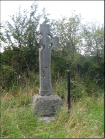
There are three High Crosses in the Castlekieran enclosure. In addition, there is the base of a fourth cross. The base was placed by the chapel in recent years. It had been in the River Blackwater that runs along the northeast edge of the monastic site. The three crosses are located respectively to the north, south and west of the small chapel on the site. They are sometimes referred to as "termon" crosses. This term refers to church lands and derives from the Latin terminus meaning boundary. (Merriam-Webster) Thus termon crosses marked the sanctissimus or most holy area of the monastery, i.e. the area around the church. (for more on the sanctissimus and other zones of a monastic site, see Management Plan for Clonmacnois p. 14) "The monks were aware that stone crosses or cross-inscribed slabs could fill the same functions as walls; the sacred space need not be hidden, but merely marked out and enclosed. The famous carved crosses of early Ireland could set the limits of a settlement, just as they marked roads and the sacred places along them. . . . Sometimes, as at Castle Kieran and Ferna Mor, crosses circled the inside of the enclosure, doubling the security of physical walls." (Bitel, p. 64)
Each of the Castlekieran crosses is sandstone. All three crosses have roll mouldings along the edges. The south and north crosses also have cylindrical shaped abutments in the armpits of the cross. (Harbison, 1992, p. 41) On some crosses, such as the Scripture Cross at Clonmacnois, these cylinders are on the ring and point toward the armpits. (See High Crosses: An Introduction above)
The South Cross:
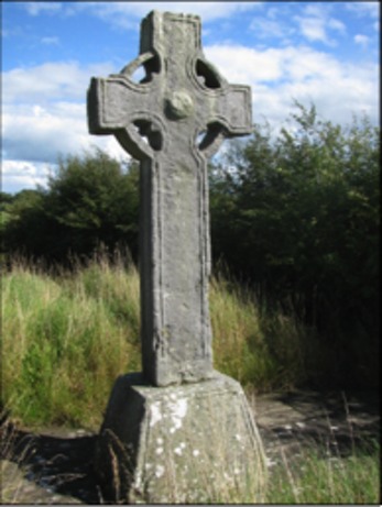
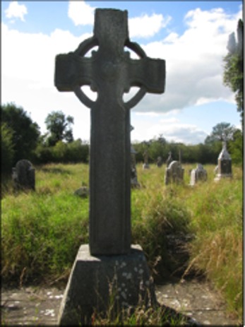
The photos above show the South Cross. On the left is the west face of the cross, and on the right is the east face.
Peter Harbison describes the South Cross as follows: "the South Cross is 2.97 m high and 1.30 m across the arms. The shaft is 49 cm wide and 37 cm thick. It stands on a base about 90 cm high and which measures 1.27 m by 87 cm at ground level. In the centre of the head of the east face there is a rounded setting bearing a boss with interlacing. The end of the north arm has a panel of loose interlace, and there is a further panel of interlace on the lower left segment of the ring. The remainder of the cross is undecorated." (Harbison, 1992, p. 42)
The North Cross:
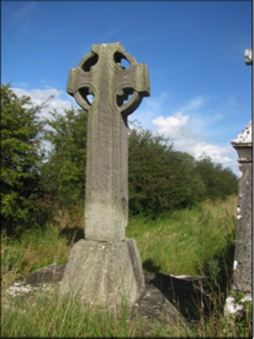
The photos above show the North Cross. On the left is the west face and on the right is the east face.
Harbison writes "the North Cross as 2.62 m high, 1.10 m across the arms, the bottom of the shaft is 53 cm wide and 47 cm thick. It stands on a base which is 75 cm high, and measuring 1.04 m by 1 m at ground level. The arms are tilted slightly upwards. The ends of the arms are decorated with interlace [visible in the photo above on the right]. On the east face the lower left segment of the ring is decorated with interlace, while the upper left and lower right segments have a 'battlemented' design which is also found on the ring on the west face." (Harbison, 1992, pp. 41-2)
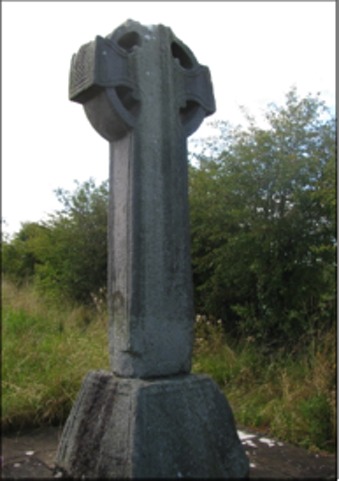
The West Cross:
The photos above show the West Cross. The photo on the left shows the east face. The photo on the right is the north face.
The West Cross is described as follows: "The West Cross is 2.08 m high. The southern arm has been broken away, but the head would have originally measured about 85 cm across the arms. The shaft is approximately 37 cm wide and 24 cm thick at the bottom. The cross stands on a slightly stepped base without mouldings; it stands to a height of about 56 cm and measures 91 cm by 75 cm at ground level. The cross is undecorated, but -- unlike the other two crosses on the site -- the plinth at the bottom of the shaft is broader than the shaft itself." (Harbison 1992, p 42)
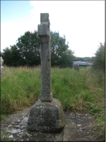
The Cross Base:
The base of a fourth cross is now located near the ruins of the old church. In the mid-nineteenth century W.R. Wilde reported two legends regarding this base and its cross.
Wilde identifies what could now be considered the east cross as the "northern one." He writes that it "was erected in a ford in the river, a very remarkable situation for one of these early Christian structures. The base still stands in its original locality, but the shaft, the arms, and the top were removed, it is said, many years ago, by some good Protestant, who, anxious to show his loyalty, as well as his detestation of such idolatrous structures, threw them into into an adjoining deep pool in the river." (Wilde, p. 138)
The second legend involves Saint Columcille. "The old tradition current among the people here concerning these crosses is, that St. Kieran had a number of them hewn at the quarry of Carrickleck, and brought here to adorn his church. They were the wonder, the admiration, and—alas ! that such a sentiment should enter into the breast of Christian saints—the envy also of all the neighbouring saints and church builders. St. Columb, who was then erecting his church and tower at Kells, cast, it is said, a longing eye upon St, Kieran's crosses: he came by night and surreptitiously abstracted at least three of these, which the traditionary legend says are those now remaining at Kells, At last, upon the night that he was taking away the fourth, St, Kieran awoke, and caught him in this very act of petty larceny, Kieran immediately 'buckled' in his brother of Kells, just as he was stepping into the ford of the river with the base of the cross on his back; but the latter being the younger and the stronger man, the cross-owner was soon worsted. He wasn't, however, to be beat so easily, so he still held fast by the thief, who, seeing that he could not get off clear with his booty, threw it into the middle of the river, from which it has never since been removed, and where, except during a heavy flood, it is always to be seen." (Wilde, p. 139)
Wilde goes on to debunk at least the second of the legends. He points out that Saint Kieran is reported by the Annals to have died in 770, a considerable length of time after the death of Columcille. (Wilde p. 140) Whether this base and its cross were originally erected in the river at a ford is unknown.
The Cross Slab:
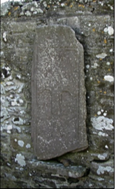
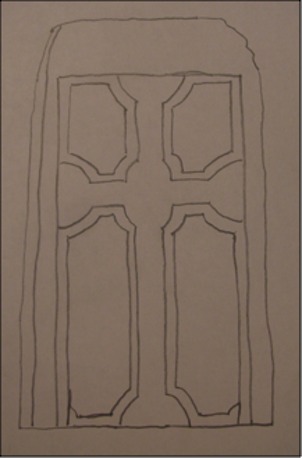
The image above is a rough tracing of a sketch of the Castlekieran Cross-Slab produced by De Noyer in 1865 and found in O'Connell p. 167. It offers a clearer sense of the image found on the Cross-Slab itself as pictured to the right.
O'Connell describes the cross-slab as follows: "It measures approximately four feet in height by two in width, and the average thickness is about three inches. . . The cross is deeply incised in double lines and displays cup-shaped terminals. It is enclosed by an incised quadrangle. There is no inscription." (O'Connell, pp. 167-168) When O'Connell viewed the cross-slab it was leaning against a tombstone. It has been moved to the church where it is suspended on the north wall.
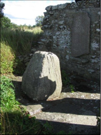
The Ogham Stone:
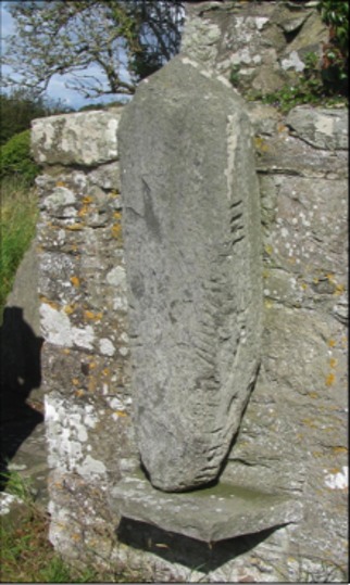
Ogham is a form of writing used in Early Medieval Ireland to write what has been referred to as Old Irish. It is sometimes known as the “Celtic Tree Alphabet” as each letter seems to be ascribed to a species of tree. Most of the inscriptions contain personal names. The extant examples of Ogham are all on stone. Other substances were certainly carved with Ogham, especially wood.
The inscription on the Ogham stone at Castlekieran (illustrated to the left) has been translated into Latin as “COVAGNI MAQI MUCOI LUGUNI” (SOCOIN/TOBI, p. 51)
The stone is mounted on a shelf on the northwest corner of the church at Castlekieran.
The Church: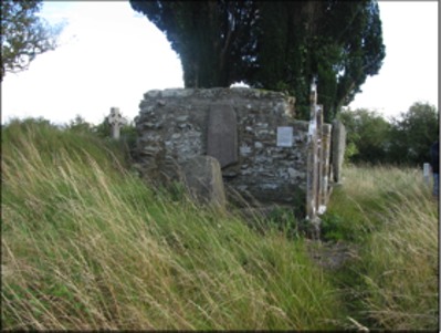
Writing in 1850, W.R. Wilde had this to say about the church at Castlekieran. "Its direction is, as usual, east and west. No doorway or window-case remains, to indicate by their style the period to which the church might be referred; but judging from the masonry, which consists of small stones and rubble-work set in an unusually great quantity of mortar, we should consider it an erection of a period not earlier than the fourteenth century." (Wilde, p. 141)
A little over a decade later, in 1862, Rev. A. Cogan, Catholic Curate of Navan described the church as follows: "The old church is quadrangular, measuring forty-five feet six inches by twenty feet. Most of the stones have been carried away, and the whole presents a melancholy picture of desolation." (Cogan, p. 125)
The church is indeed desolate. The entire graveyard is covered by tall grass. This growth is especially heavy on the east side of the church.
Saint Kieran's Well:
Kieran’s Well is located near the old monastic site of Castlekieran, not far to the west. The origin of the spring is near the top of a steep hill and the site is adjacent to the road. It flows down through stone that the water carved over the years forming a stream at the lower end of the site. Tradition suggests the water has curative powers, especially for tooth-aches and headaches.
"There was a big whitethorn bush over the well and long ago a big spoon or scoop was hung on the whitethorn bush which overhung the well. People came there regularly to drink the water and to bottle it to take away for use at home". (askaboutireland.ie)
Writing in 1850 W.R. Wilde had this to say of the well. "About a furlong's length to the west of the old church may be seen springs from a limestone rock of considerable extent; and appears first in a small natural basin immediately at the foot of the tree.
"Within the well are several trouts, each about half a pound weight. They have been there " as long as the oldest inhabitants can recollect," and, strange to tell, they are said not to have grown an ounce within that period. These fish are held in the highest veneration by the people, who, when the well is being annually cleansed of weeds, carefully preserve the blessed creatures, and replace them as soon as possible." (Wilde p. 142)
Getting There: A Personal Reflection
The Castlekieran monastic site is not only off the main roads, it is also invisible from the road. As usual, my wife and I, when searching for High Crosses, had a general idea of where the site was. We were sure we could get within a few kilometers at the most. We took the R 147 west out of Kells. After about three miles without any sign posting for Castlekieran we followed our typical pattern. We stopped to ask directions from a local. In this case it was a young man in the front garden of his home. He knew the Castlekeran site and gave us directions on how to get to the right road.
The route was still a bit confusing, but we were pretty sure we were on the right road when we came to Kieran's Well on the left side of the road. We stopped there to enjoy the beauty and spirituality of the place before continuing on to search for the monastic site. My wife was keeping an eye out on the left and as much as possible I kept an eye out on the right while driving slowly. We were looking for any sign of an old graveyard. We didn't see one. At one point, we stopped in the driveway of a two story yellow farm house to consult the maps we had with us and review the directions we had received.
After another half mile we saw a woman standing in her driveway beside her car. I stopped, got out and began to walk across the road to ask if she could give us further directions. As I did this, a young boy of perhaps five or six got out of the car. He saw me coming and called out to me, "Are you looking for Barney?" I found this amusing because, of course, my name is Barney, and I said so as I approached the lad. It turned out that the woman was his grandmother and that his grandfather was known as Barney.
The grandmother gave us very exacting directions. They went something like this, "Go back the way you came. You will pass a two-story farm house on the right that is occupied. Then you will come to another two-story farm house on the right that is derelict. When you come to the third two-story farm house on the right, a yellow house, stop just before you reach their driveway. You will see a gate that leads into their farm yard. Go through that gate and through the farm yard and you will come to the edge of a field. Across the field you will see the cemetery where the crosses are located."
Of course the two-story yellow farm house was the same house where we had stopped in the driveway less than twenty minutes before.
References cited:
Askaboutireland.ie www.askaboutireland.ie/reading-room/history-heritage/folklore-of-ireland/the-holy-wells-of-meath-f/keenahene-loughan/
Bitel, Lisa M., Monastic Settlement and Christian Community in Early Ireland, Cornell University, 1990.
Celt, Corpus of Electronic Texts, http://www.ucc.ie/celt/publishd.html, Annals of the Four Masters.
Cogan, A. Catholic Curate, Navan, The Ecclesiastical History of the Diocese of Meath, the Diocese of Meath Ancient and Modern, Vol. 1, Dublin, John F. Fowler, 1862.
Harbison, Peter; The High Crosses of Ireland: An Iconographical and Photographic Survey, Dr. Rudolf Habelt GMBH, Bonn, 1992. Volume 1: Text, Volume 2: Photographic Survey; Volume 3: Illustrations of Comparative Iconography.
The Monastic City of Clonmacnoise and its Cultural Landscape, Management Plan 2009-2014, prepared by The Office of Public Works and Environment, Heritage and Local Government, 2009.
Merriam-Webster on line dictionary, www.merriam-webster.com/dictionary/termon
NewAdvent.org, Kieran, Catholic Encyclopedia.
O’Connell, Phillip, “A Castlekieran Cross-Slab”, The Journal of the Royal Society of Antiquaries of Ireland, Vol. 87, No. 2 (1957), pp. 167-168. http://www.jstor.org/stable/25509289
SOCOIN/TOBIN Consulting Engineers, "Response to An Bord Pleanála Kingscourt to Woodland Route Comparison Report" Prepared for EirGrid, 2008
Wilde, William Robert, The Beauties of the Boyne, and its Tributary, the Blackwater, James McGlashan, London, 1850. http://ia600300.us.archive.org/17/items/beautiesofboynei00wild/beautiesofboynei00wild.pdf