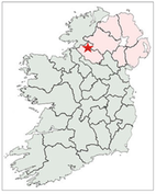
This article discusses the High Crosses of County Fermanagh, and where possible the history of the site and the identity of the founding saint. These crosses are located at Aghanaglack, Boho, Galloon, Inishkeen, Inishmacsaint, Kilcoo, Killesher and Lisnaskea.
General Background
The area now called County Fermanagh was a habitat for hunters and gatherers of the Mesolithic, though few artifacts from that period have been found. More productive archaeologically is the evidence for Neolithic farming communities. Court tombs from that period have yielded pottery, scrapers, javelins and stone beads. Some, such as the site at Tully date to 2700 BCE. While settlement evidence is lacking for the Bronze age, some bronze items have been found, items like rappers and swords. (Williams p. 16-17)
In the Iron Age, Celtic peoples and culture became dominant, with cattle-rearing, tribal structures, epic tales, ornamental artwork and the first written language, Ogham, recorded on standing stones. (Rootsireland website) Iron Age finds include burials and stone carvings.
Figure carvings, like those at White Island in Lower Lough Erne, date to the early Christian period in about the 9th or 10th century. As we discover below, there were numerous early monastic sites in what is now County Fermanagh, and some of these include high crosses. (Williams pp. 16-18)
Politically one of the primary clans in the area during the early Christian period were the Fir Manach, who gave their name to County Fermanagh and County Monaghan. From around 700, they were in the territory of the Northern Ui Neill to their north and the Airgialla to their east.
Viking raiders penetrated Lough Erne in the ninth century and are reported to have attacked monasteries on and along the lake, including Devenish, in 837, and returning at times over the next century or so.
“By the end of the 11th century, Fermanagh had decisively re-emerged as a sovereign kingdom in the region. The rulers of this kingdom were drawn from the Airgialla.” https://en.wikipedia.org/wiki/Fermanagh This brings us to the end of the period of the Irish High Crosses at 1200 CE.
Ecclesiastic History
Numerous churches and monastic sites were located in present day County Fermanagh. While the dates of formation are not uniformly know, several appear to have been founded in the 6th century. Some of these are listed below. The list is not exhaustive as several monastic sites where there are High Crosses or fragments of crosses are not listed below. These include Aghanaglack, Galloon, Inishkeen, Killesher and Lisnaskea.
The source for the listing of Monasteries below is: https://en.wikipedia.org/wiki/List_of_monastic_houses_in_County_Fermanagh
Aghalurcher Monastery:Founded by St. Ronan in the 8th C.
Aghavea MonasteryAn early monastic site
Aredmuilt MonasteryAn early monastic site
Boho MonasteryAn early foundation.
Devenish MonasteryFounded before 571 by St. Molaise Laisre); a Culdee monastery from the 10th century; in 1130 a foundation of the Augustinian Canons Regular moved in adjacent jot the Culdee house
Iniseo MonasteryFounded before 777 by St. Constans
Inishmacsaint MonasteryFounded in the 6th century by Saint Ninnidh Laimhdhearg
Inisrocha MonastgeryAn early foundation listed as an abbey
Kilcoo MonasteryAn early foundation possibly founded by St. Patrick
Kilterney MonasteryA possible early site.
Kinawley MonasteryFounded before 563.
Lisgoole AbbeyBuilt on the site of an early monastery became Augustin ian Canons Regular in 1106?
Magheracross: Apparently early, a Culdee site.
Pubble Monastery: An early site.
Rossory Monastery: An early site for nuns, founded before 480 by St. Frfanchea
Tivealough Monastery: A possible early site that may have become Franciscan in the 12th century.
White Island Monastery: A possible monastic site.
At the Synod of Rathbreasail in 1111, when the Irish church was brought into conformity with the organization of the Roman Church, what is now County Fermanagh became part of the Diocese of Clogher, which is in the present county of Tyrone.
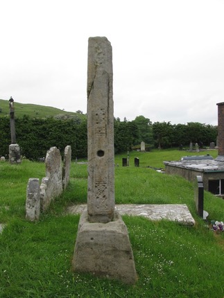
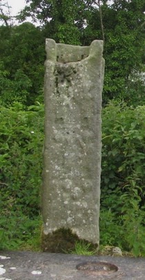
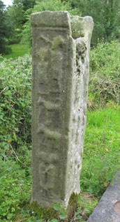
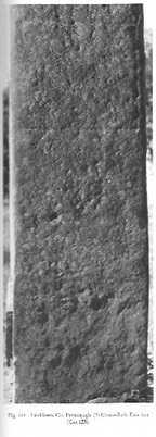
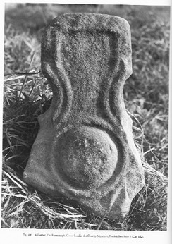
Aghanaglack Cross
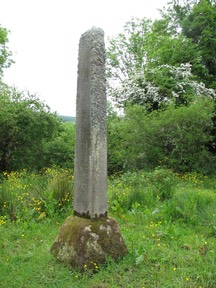
This cross shaft is located in the townland of Boho. Aghanaglack has the meaning of “field of the hollow”. I find nothing related to the history of the site or any saint associated with the foundation of a church or monastery there.
The sandstone cross shaft is about seven feet (2.1 m) tall. There may have been roll-mouldings at the corners and the faces of the shaft may have been divided into panels. Due to weathering, any definitive description is impossible.
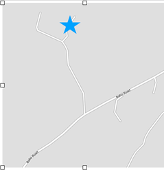
Getting There: See the Road Atlas page 17, A2. The shaft is tricky to find. It is located just off the road from Belcoo to Boho, about 5-6 km from Belcoo in a section of the road that runs southwest to northeast. There is a lane with two paved runners on the north side of the road. It branches part way up. Stay right and the shaft is in a small field close to the track. This is identified on the map with a star. The map is from Google Maps.
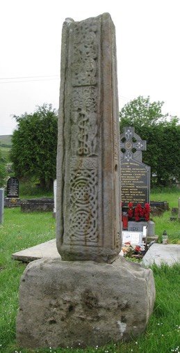
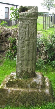
Boho Cross
Introduction to the Site
The ecclesiastic site at Boho has been in use since the Early Christian period. It is presumed that it was the site of a monastery or nunnery. (Donnelly, 2002, p. 4) There are at least two pieces of evidence that point in that direction.
First, the presence at Boho of a High Cross suggests this was an ecclesiastical site. It also indicates that the foundation was relatively prosperous when the cross was erected. The dating of the cross is a subject of some debate. Francoise Henry, based on similarities to the Drumcliff Cross, County Sligo, suggested a date for the Boho Cross in the 11th century. (Harbison, 1992, p. 374) Peter Harbison suggested that it belongs instead to the 9th century due to similarities with the Cross of Saints Patrick and Columba at Kells, County Meath (Ibid, p. 372) and to the Drumcliff Cross, County Sligo, which he gives an earlier date than Francoise Henry. (Ibid, p. 375) This does not, however, give us a date for the establishment of the monastery or nunnery which we can assume must have been 9th century at the latest.
Second, Church lands continued to exist at Boho in the 15th century, in the form of a parish church, as indicated by a reference in the Annals of Ulster to the presence in 1483 of an erenagh. (Donnelly, p. 4) The erenagh was an officer in the medieval period who was responsible for receiving parish revenue, overseeing parish land and building and maintaining church property.
The earliest reference to the High Cross belongs to 1834, when Captain Alexander Henderson reported in the Ordnance Survey Memoirs for the parish that: ‘in the townland of Toneel near the site of an old monastic building there is a stone about 5 feet high and about a foot and a half by 6 inches, rudely carved on each side, but the figures, though in tolerable good relief, are not sufficiently characterised to warrant anything more than conjecture as to whom they were intended to represent’”. (Donnelly, 2002, p. 5)
The Boho cross is one of only a few to be excavated in Ireland and the first in Ulster. (Donnelly, 2003, p. 129) This excavation indicated that the cross has probably been moved from its original position. This probably occurred in the early 1800’s when the new church was constructed. “It is probable that this construction process would have disturbed human remains. It is also reasonable to suggest that the workers may have encountered pieces of a collapsed high cross -- its foundation slab, socketed base and shaft -- during their work. It is worth noting that local folk-lore relates how the high cross arrived in Boho ‘overnight’ (John Curran pers comm). It can be suggested, therefore, that a new location was required for the newly discovered cross and that the highest point in the graveyard was deemed appropriate, to the west of the new church. A pit was excavated and the bones and coffin pieces disturbed by the building work were gathered together and placed into it. This charnal pit was then covered with a mixed graveyard soil and the high cross was re-erected on top.” (Donnelly, 2003, p. 130)
The Saint
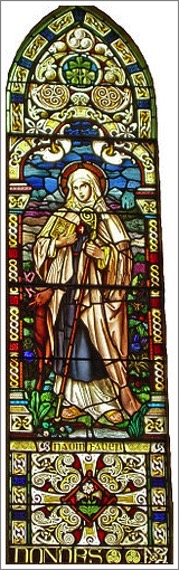
Saint Faber (Feadhbar) is patron saint of the Sacred Heart Church in Boho. Whether she founded a monastery or nunnery there or whether it was later dedicated to her is not known. She is mentioned in The Martyrology of Oengus the Culdee, written about the beginning of the 9th century as “Fedbair a virgin of Botha.” (The Martyrology of Oengus the Culdee, London: Henry Bradshaw Society, 1905, pp. 240-241) It is said that Saint Faber introduced Christianity to the area. She is often shown with a deer that was reputed to be her pet. The image to the left is a stained glass window in the Church of the Sacred Heart that honors her. There is a deer standing by her side. (http://www.bohoheritage.com/about-boho/boho-high-cross/ 10/2013).
Images on the Cross
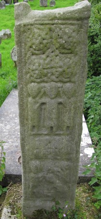
A general examination of the cross reveals the following information. The shaft of the cross is just over 6 feet (1.88 m) high. There is roll moulding with a narrower moulding inside it on the edges of the cross. The panels of the cross are not clearly divided as is frequently the case on other high crosses. On each of the sides there is a hole located about 24 inches (60 cm) up the shaft. It is presumed this would have held a tie-piece connected in turn to a vertical strut that would have supported the arms of the cross. Similar holes are found on the Drumcliff Cross in County Sligo which is closely related to the Boho cross by its iconography. (Harbison, 1992, p. 28)
Following an excavation in 2002 to straighten the cross, it was found that the base is about 21 inches (0.80 m) high and 38 inches (0.97 m) (north-south) by 30 inches (0.77 m) (east-west). (Donnelly, p. 10) These measurements increased the previously known height of the base by some 7 inches (18 cm). (See Harbison, 1992, p. 28)
East Face
The east face of the cross is seen in the photo to the right.
The lower portion of the shaft (left) contains interlace. The interlace begins with two circular patterns linked together by lines of the interlace and crowned by a simple two-strand interlace pattern.
Above the interlace design is a small band of fret pattern.
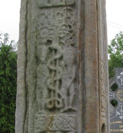
The center section of the shaft (right) contains an image of Adam and Eve. It is a depiction of part of the story of The Fall told in Genesis chapter three. In this scene, Adam and Eve stand under a tree that has a double stem. The tree spreads out above them. The left hand figure is Eve and the right hand figure is Adam, who is sporting a beard. Each of them, with one hand, covers their nakedness. This places the scene after the eating of the forbidden fruit, when they knew they were naked. (Genesis 3:7) Eve appears to stretch out her right hand to Adam. Adam appears to have his right hand up beside his cheek. The serpent winds its way up the tree and faces Eve. (Harbison, 1992, pp. 28-29)
The upper portion of the shaft (left) is decorated with “irregular spiral motifs.” (Harbison, 1992, p. 29)
South Side
The south side of the cross shaft (right) is partly decorated. Beginning at the bottom, there is interlace in the form of two circular devices. The second panel is undecorated It contains a hole, the purpose of which is described above. The third panel is in disrepair but appears to be composed of interlace. The fourth panel up is undecorated. The fifth panel contains badly worn interlace.
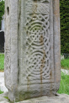
West Face
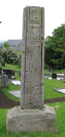
The west face of the cross is pictured to the left.
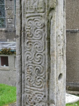
The bottom panel (below left) consists of interlace similar to that on the east face, lower shaft. In this case the pattern contains six spiral devices rather than two. They are interconnected.
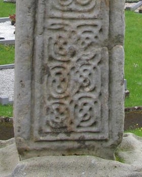
The second panel (below right) contains “pelta-shaped curves” that are interlinked. In the spaces left along the edges there are small bosses. The clearest of these can be seen in the lower right of the image below. (Harbison, 1992, p. 29) Pelta is the Greek for shield. There is a class of pelta-shaped shields that are elliptical in shape.
The third panel (left) has been interpreted as depicting the Presentation of John the Baptist in the Temple. (Lk 1:59) The figure in the center of the panel is taken to be Elizabeth, the mother of John. She is seen to hold a child in front of her. While the figures on either side are not identified by Harbison, they may be taken as Zechariah, John’s father, and another priest of the temple.
Though the scene above this (below right) represents the baptism of Jesus, this image is not identified as the presentation of Jesus. (Lk:2: 21-32) In part this is due to the positioning of the Mary figure. In most images of the presentation of Jesus, Mary and Simeon are both shown in profile. (Harbison, 1992, p. 236-7)
The fourth panel (right) represents the Baptism of Jesus. (Mt. 3:13-17) There are three figures. Christ stands in the center and faces John the Baptist on the right. John appears to stretch out a hand toward Jesus. The figure behind Jesus may be an angel and it is possible there is a dove above Christ’s head to represent the Holy Spirit. The pattern at the bottom of the panel represents the River Jordan, where Jesus was baptised. (Harbison, 1992, p. 29)
North Side
The north side of the cross (left), like the south side is partly decorated. At the bottom of the shaft there is a small circular pattern of interlace. The second panel is undecorated and like the south side, contains a hole. The third panel is interlace. The fourth panel is undecorated. The fifth panel is interlace.
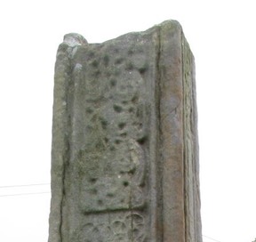
Arm Fragment
Located in the church under the pulpit is a fragment of a cross arm (right) that was found near the base of the cross. Similarities with the moulding pattern on the edges of the cross shaft make it probable the arm belongs to the cross. On one face (not illustrated) whatever pattern there may have been has worn off. On the other side (right) there is what appears to be interlinked bosses from which small animal-heads emerge.” (Harbison, 1992, p. 29) Obviously most of the head of the cross is missing and the arm fragment shows no sign of a ring.
Getting There: See the Road Atlas page 17, A2. Located in the graveyard behind the Roman Catholic Church of the Sacred Heart. Follow signs to Boho from the A4 west of Enniskillen. The map to the right indicates the location in the upper left corner. It can also be reached by taking the B81 west from Enniskillen. The distance is about 10 miles. The map to the right was prepared by a team of archeologists who conducted an excavation of the cross in 2002. (Donnelly, 2003, p. 122)
Galloon Crosses
The Site
Writing in 1934, Lowry-Corry described four cross related items at Galloon and noted that these crosses were relatively unknown. Not long before a bridge had been constructed, offering access. She notes that the crosses were unknown to Henry Crawford, Kingsley Porter and Francoise Henry, early High Cross scholars. Lowry-Corry described the East and West crosses (shafts and bases), a head fragment (crossing and partial arm) and a ring fragment. In 1941, Oliver Davies identified an additional fragment that was photographed and described by Ann Hamlin in 1966. It has since disappeared. (Hamlin, p. 54)
The Saints
Tradition states that a monastery was founded on the island by Saint Tigernach in the early sixth century. Tigernach left the monastery to found a monastery at Clones, leaving St. Comgall in charge. (Lowry-Corry, p.165) The Latin Life of Tigernach of Clones confirms this, but was written much later. The Annals of Ulster note the death of Tigernach under 549 and 550. The site of the monastery is now occupied by a graveyard. (Hamlin, p. 54) For more on Saint Tigernach see the article on Clones under Monaghan Crosses.
The following descriptions reflect the work of Peter Harbison with some additions from Lowry-Corry.
East Cross
This cross shaft stands about 4 feet (1.2m) tall. One of the head fragments described below may have belonged to this cross.
East Face
1: Sacrifice of Isaac
E 2: Interlace forms two circles
E 3: The Resurrection or from Lowry-Corry, Moses, Aaron and Hur.
E 4: Four interlaced circular knots. (Lowry-Corry, p. 169)
The images left and right are from Harbison, 1992, Vol. 2, Figs. 290-293.
South Side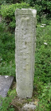
Fret pattern terminating in small bosses with a quadruped facing downward. There may once have been an inscription “Maelchiarain” recorded by Macalister.
West Face
W 1: Adoration of the MagiW 2: Baptism of Christ
W 3: Saints Paul and Anthony breaking Bread in the Desert
North Side
N 1: Samuel Kisses Saul or David or (Lowry-Corry) The Return of the Prodigal SonN 2: Two animals, a dog above a goat.
N 3: Samuel Anoints Saul or David. Lowry-Corry interprets N 2 and N 3 as one scene. “Here are two animals placed one above the other, with above them two Figures standing more or less side by side, the interpretation of which puzzled me very much. But Dr. Macalister has suggested that we have here a most unusual and interesting representation of the Resurrection of the Dead, and Last Judgment. One of the two Figures is blowing a trumpet, and so is evidently intended for an Angel. He stands at a slightly higher level than the other Figure who, with his arms crossed in front of him, must be intended to be rising from the Dead. The animals below are evidently a sheep and a goat, symbolical of the saved and the lost.” (Lowry-Corry, pp. 169-170)
West Cross
This cross shaft stands a little over 4 feet (1.2m) in height. A thick box at the top has a large mortise hole. The edges are squared.
East Face
E 1: Baptism of Christ with "John the Baptist on the left pouring water over Christ in the centre, as an angel looks on on the right.” (Harbison, 1992, p. 92) Lowry-Corry interprets this as The Temptation of St. Anthony. (Lowry-Corry, p. 171) Both identifications are offered as tentative.E 2: Daniel in the Lions’ Den
E 3: Adam and Eve
E 4: Decoration in the box is too worn to identify.
South Side
Harbison states that the images here are too worn to venture a guess as to the content. Lowry-Corry reports that Macalister identified an inscription on S 1 that may translate as “A Prayer for Dublitir.” A Dubhlitir, historian and abbot at Clones, died in 877 or 879 according to the Annals. This inscription suggests a dedication and general date for the cross.
S 2: Two figures leaning together with legs crossed may represent Jacob wrestling the with Angel or the Return of the Prodigal Son.
S 3: Two human figures too defaced to identify.
S 4: May be David breaking the jaws of the Lion or Samson and the Lion.
Box: Was carved, perhaps with figures. (Lowry-Corry, p. 171-172)
West Face
W 1: The Three Children in the Fiery Furnace
W 2: The Sacrifice of Isaac
W 3: Noah’s Ark
Box: Too worn to identify.
North Side
Bottom: It is here that Harbison reports Macalister once reading the inscription “ ublitir". This is in contradiction to Lowry-Corry who states this was seen on the South side of the cross.
N 1: Six bosses
N 2: An animal facing downward with forward-pointing legs.
N 3: Two unidentified figures. Lowry-Corry tentatively identifies this as "two Zoomorphic Figures of a dragonesque type.” (Lowry-Corry, p. 171)
Box: Nothing visible.
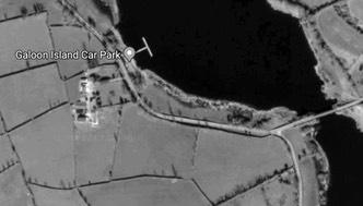
Getting There: See the Road Atlas page 17, C4. Located Southeast of Enniskillen, Southwest of Newtownbutler. On the Southside of Newtownbutler, go right on a road (Galloon Road) beside St. Mary’s Primary school. Follow the road about 5 km. After crossing a bridge there is a graveyard on the left, near the Galloon Island Car Park. The map to the right is cropped from Google Maps.
Head Fragment
The photographs below shows the cross fragment as it appeared in 1934 when Lowry-Corry described it. We have the center of the cross, one arm and a part of the ring. According to Harbison, the center of the head is now missing and the rest was removed in the 1990’s to the Department of the Environment’s store in Enniskillen.
East Face
On the face that Harbison designated “east” there is an image of Daniel in the Lion’s Den in the center. In the contraction of the arm are bossed spirals. Out of two of them animals appear to emerge. On the arm are two figures, reminiscent of a panel on the cross-head at Clones. It may represent Joseph and the Pharaoh’s Butler.
West Face
In the center is an image of the Crucifixion that includes the figures of Stephaton offering vinegar and Longinus piercing Christ’s side. The contraction of the arm appears to have animal interlace or bossed decoration. The arm depicts a central figure flanked by smaller figures. It probably depicts the thieves crucified with Jesus. On the end of the arm is a single figure. The bottom of the arm contains a fret pattern.
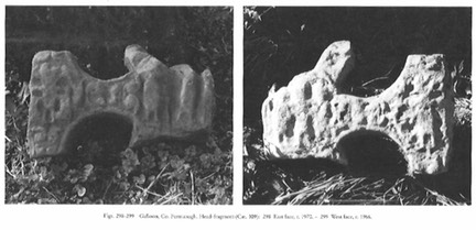
Ring
The decoration is unidentifiable. Lowry-Corry described a portion of ring, now missing, that bore interlace.
Images to the right are from Harbison, 1992, Vol. 2, Figs 298, 299.
Lost Cross Head Fragment
This lost fragment was photographed by Ann Hamlin in about 1966 and is since missing.
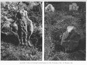
East Face
The Second Coming of Christ or the Last Judgment. A central figure with a staff held across the body diagonally is flanked by the head of a figure on each side.
West Face
The Crucifixion. Jesus with arms outstretched with Stephaton on the left offering vinegar. Longinus is probably to be understood to be on the right.
Images to the left are from Harbison, 1992, Vol. 2, Figs 300, 301.
Inishkeen Cross
This cross shaft is located in the Parish of Enniskillen, about two miles south of the city of Enniskillen. Tradition tells us that the first bishop of the area was Saint Macartan who lived about 500. The early churches were located on islands or along the shores of Lough Erne. Inishkeen was one of these churches. The patron saint of Inishkeen was Saint Fergus. In later years the parish priests held the title of Dean of Lough Erne. One of them, Cahal McManus compiled the Annals of Ulster in the late 15th center. (http://www.st-michaels.net/theparish.htm)
Father Patrick Comerford tells of Saint Macartan. Saint Macartan, was a member of the early generation of Irish saints. He was both the first Bishop of Clogher and an uncle of Saint Bridget. He was known as Saint Patrick’s “Strong Man” because of his dedication and faithfulness. Saint Macartan grew up as Aidus. He was the son of Caerthen, and so continued to be known after his conversion as Macartan. When he heard of Saint Patrick’s mission, Aidus travelled south from his father’s home to hear him preach. There Macartan was baptized and he soon became one of Saint Patrick’s missionaries. Saint Macartan died in the year 506 and his feast day is celebrated on 24 March. (http://www.patrickcomerford.com/2013/03/with-saints-in-lent-40-saint-macartan.html) Found in 2006.
The photo to the right is from Harbison, 1992, Vol. 2, Fig. 324.
The cross shaft is carved from sandstone and stands on a base. The shaft is about four feet tall. There are incised lines on the east face and north side that create panels. They no longer bear any decoration.
Getting There: Located about 2 km south of Enniskillen. From the A 4 just south of LoughYoan an unnamed road goes south. The present owner of the land tends not to allow visitors. No map is provided.
Inishmacsaint Cross
The name, Inis-maige-samh, translates as “the island of the sorrel plain”. The founding saint, Ninnid, lived in the 6th century and according to much later sources studied with Finnian of Clonard and was a contemporary of Ciaran of Clonmacnois, Molaise of Devenish and Aiden of Ferns, but these sources are too far from his lifetime to record more than traditions An abbot of Inishmacsaint, Fiannamail, was killed in 718, and the monastery was probably laid waste by Viking raids during the 9th and 10th centuries. By 1306 Inishmacsaint was a parish church, occupying the early monastic site.
A roofless church on the island is shown in a 1609-10 map, and it was probably still ruined in 1622, when there was a complaint that ‘the old church standeth in an inconvenient place’.
The church shows work of three periods. Earliest is the west part, which may represent a small, pre-Romanesque church, perhaps of the 10th or 11th century. Remodeling was done in the 13th century and again in the later middle ages.
"The cross stands just SW. of the church. It is tall, 11 feet (3.36m), thin and rather plank-like, its two stones joined at the head with a mortice-and-tenon joint, visible in the break on the E. side. The head is of unusual form, lacking a ring and with the arms hollowed in very shallow curves. A third stone is missing to complete the top member: a mortice hole exists to hold it. In good light it is possible to see faint traces of rectangular panels on the ends of the arms and under the arms, but the general impression is severely plain. The cross is difficult to parallel and to date: between the 10th and 12th centuries seems likely, but it could be later." (http://www.doeni.gov.uk/niea/whiteisland.pdf) The base on which it stands is 27.5 inches (70cm) tall.
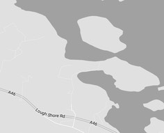
Getting There: See the Road Atlas page 17, A1. Located on an island with a road to it in Lower Lough Erne to the northwest of Enniskillen along the A46. The final approach is by foot down a farm path and across a pontoon bridge to the island. The map is cropped from Google Maps,
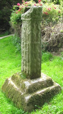
Kilcoo Cross
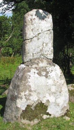
The base and shaft together stand about 4 feet (1.2m) in height. The shaft has roll moulding but no trace of any decoration. (Harbison, 1992, pp. 113-114)
Writing in 1879, W. F. Wakeman, in an article on Kilcoo, wrote of his surprise that “absolutely nothing appears to be know about it.” The same seems to be true as I write, over 130 years later. He goes on, “and still here, within a small compass, we find the relics of an ancient church, a holy well called ’tober Patrick,’ a very curiously-circumstanced stone cross of primitive character, a number of ancient Irish inscribed flag-stones, a well-defined leact, or monumental heap, and a cavern in the limestone immediately adjoining . . . which . . . was anciently, like St. Kevin’s Bed at Glendalough, partially fashioned by human hands, and used as a penitential retreat.” (Wakeman, pp. 24-25)
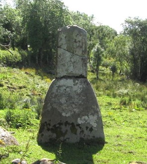
Wakeman considered the location of the cross base and shaft to “combine the pagan idea of a monumental leact with that by which our earliest Christians were moved when they desired to design a sepulchral memorial.” He describes the mound as being composed of earth and small stones. There is a circle of ten stones that surround the base of the cross. The base and cross are carved of red sandstone. (Wakeman, p. 33)
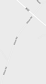
Getting There: See the Road Atlas page 16 G2. From Belleek take the B52 southeast to Garrison. Between 3 and 4 miles southeast of Garrison at Kilcoo Cross Road, the Kingfisher Cycle Trail, go south a little over a mile. The Cross base and partial shaft are to the west. The map is cropped from Google Maps.
Killesher Cross
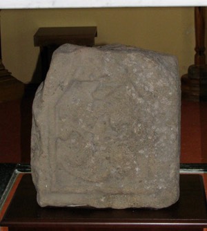
Cell Lasair was a monastic site connected with the female Saint Lasair. Tradition mentions her blessing a “stately church” at the head of Loch Mic nEn. The ruins of the church and a graveyard overlook Lough Macnean Lower. The cross fragment was first mentioned in 1944 by Oliver Davies. It was found again in 1977 by Helen Hickey, curator of Fermanagh County Museum in Enniskillen. It is now in their possession. It has not been on display for several decades.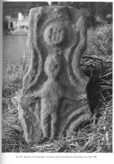
Saint Lasair is a name given to more than a dozen Irish saints. There is a Life of Saint Lasair that dates to the 17th century. Our particular Lasair seems to be the one described in the life. She was descended from Niall of the Nine Hostages, monarch of Ireland (d. 405). She is also mentioned as patroness of Aghavea, nearby.
Hamlin describes the fragment as ringless with an angle roll and an inner half-round moulding. There does not appear to have been a finial. On one face is a figure with arms outstretched. Below the arms on each side is a triangle. Above the head is a boss that was decorated. The other face has a central boss as well as moulding. There may have been some decoration, but that is difficult to assess. There is no decoration on the sides. She goes on to suggest a date in the 11th or early 12th century. (Hamlin, pp. 53, 54)
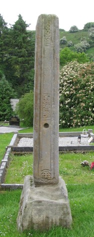
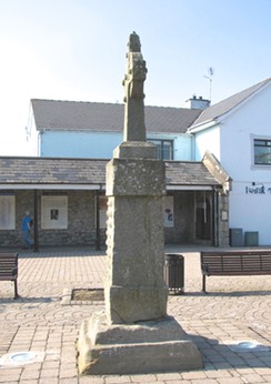
Lisnaskea Cross
The original site of this cross is unknown. What is fairly certain is that it was not Lisnaskea as there was no monastic foundation there. Galloon, Inishroosk and Aghalurcher have been mentioned as possibilities. One tradition is that the shaft was used for swearing oaths and was located at a crossroads nearby and that the base was at one time used as a mounting block at Castle Balfour.
The cross as we see it now was erected in the Corn and Potato Market in 1841. The small cross on top was made and placed atop the ancient shaft at that time. In 1980-81 it was moved to its present location in the Corn and Potato Market as part of a restoration scheme. (Fischer)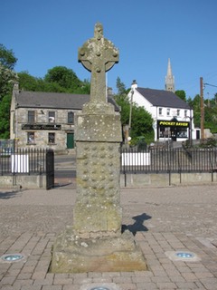
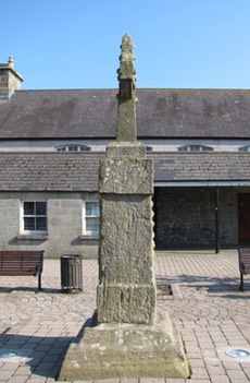
The photo to the right is the West Face of the Cross.
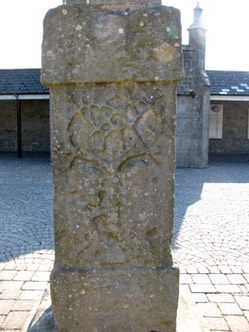
Base: The base is composed of one stone with an upper and lower section. It is uncarved.
Shaft: The shaft is also one stone. At the top and bottom there is a rectangular block. The upper one was apparently a socket for the head. The two sides are undecorated.
East Face: On the east face we have a carving of Adam and Eve beneath the Tree of Knowledge. Adam is on the left and is depicted with a beard. Eve on the right seems to be holding the apple. What may be the head of the serpent is at the top of the tree trunk. The branches of the tree are above the heads of Adam and Eve and are more realistically depicted than in other such scenes at Boho and Drumcliffe, for example.
The photo to the left is the East Face of the cross shaft.
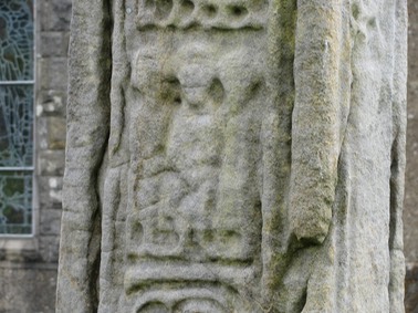
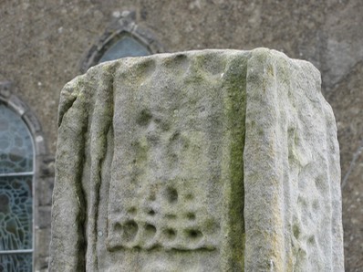
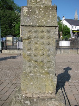
West Face: The west face contains thirty-two small circular bosses in eight rows of four each. There may once have been some sort of interlace that connected the bosses. (Lowry-Corry, pp. 153-54)
The photo to the right is the West Face of the cross shaft.
Lowry-Corry dates the cross to the ninth or tenth century. (Lowry-Corry, p. 155)
The photos left and right are the sides of the cross, the south side on the left, the north side on the right.
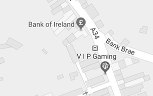
Getting There: See the Road Atlas page 17, C3. Located in the Old Corn and Potato Market along the A34 in Lisnaskea. It is located southeast of the traffic circle near the Bank of Ireland. It is on the southwest side of the street. The Market is essentially a large courtyard on the east side of the road. On the map to the right the VIP of VIP Gaming is in the courtyard. The map is cropped from Google Maps.
Resources Cited
Boho Heritage: http://www.bohoheritage.com/about-boho/boho-high-cross/
Donnelly, Colm; Macdonald, Phillip; Murphy, Eileen; and Beer, Ncholas; Excavations at Boho High Cross, Co. Fermanagh, Data Structure Report: Boho High Cross, Toneel North, Co. Fermanagh, 2002.
Donnelly, Colm; Macdonald, Phillip; Murphy, Eileen; and Beer, Ncholas; Excavations at Boho High Cross, Toneel North, County Fermanagh, Ulster Journal of Archaeology, Third Series, Vol. 62, (2003), pp. 121-142.
Fischer, William Jr., Lisnaskea Market Cross: http://www.hmdb.org/marker.asp?marker=72653
Hamlin, Ann, “Two Cross Heads from County Fermanagh: Killesher and Galloon", Ulster Journal of Archaeology, Third Series, Vol. 43 (1980), pp. 53-58.
Harbison, Peter; "The High Crosses of Ireland: An Iconographical and Photographic Survey", Dr. Rudolf Habelt GMBH, Bonn, 1992. Volume 1: Text, Volume 2: Photographic Survey; Volume 3: Illustrations of Comparative Iconography.
Lowry-Corry, Dorothy, “The Market Cross at Lisnaskea”, The Journal of the royal Society of Antiquaries of Ireland, Seventh Series, Vol. 5, No. 1 (Jun. 30, 1935), pp. 153-156.
Lowry-Corry, Dorothy, “The Sculptured Crosses of Galloon”, The Journal of the Royal Society of Antiquaries of Ireland, Seventh Series, Vol. 4, No. 2, (Dec. 31, 1934) pp. 165-176.
The Martyrology of Oengus the Culdee, London: Henry Bradshaw Society, 1905, pp. 240-241.
Roots Ireland website: http://www.rootsireland.ie/irish-world-family-history/fermanagh-history/
Saint Macartan: http://www.patrickcomerford.com/2013/03/with-saints-in-lent-40-saint-macartan.html
Saint Michaels Parish: http://www.st-michaels.net/theparish.htm
Wakeman, W. F., “Kilcoo”, The Journal of the Royal Historical and Archaeological Association of Ireland, Fourth Series, Vol. 5, No. 37 (Jan., 1879), pp. 24-34)
White Island and Inishmacsaint: http://www.doeni.gov.uk/niea/whiteisland.pdf
Williams, Brian, ‘Archaeological Sites in Fermanagh,’ Archaeology Ireland, Vol. 1, No. 1 (Sep., 1987), pp. 16-19