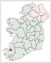
This article discusses the High Crosses of County Kerry, and where possible the history of the site and the identity of the founding saint. These crosses are located at Killiney, Kilmalkedar, Magharees Islands, Reenconnel, and Tonaknock. These crosses are the ones listed by Peter Harbison in his 1992 publication on the High Crosses of Ireland. The location of County Kerry is indicated by a red star on the map to the right.
In the case of County Kerry there is also basic information, and where possible a photograph of additional crosses listed by Henry Crawford in his 1907 article “A Descriptive List of the Early Irish Crosses. Crawford did not define the term “early”. He simply noted that he includes only “actual crosses — not cross slabs”. (Crawford, p. 187) These crosses are: Kilbeg/Ballincolla, Blasket Islands/Inishtooskert, Dunquin/Ferriter’s Quarter, Fahan/Kilvickadownig, Templebeg, Skellig Michael (7 foot), Skellig Michael (5 feet). Crawford also notes the presence on Skellig Michael of numerous small, crude crosses, many of them around the monks graveyard.
Historical Background of County Kerry
Pre-Christian Habitation
Isabel Bennett, in her article “The Archaeology of County Kerry” discusses some of the history of human habitation in what is now County Kerry in the pre-Christian era. Humans have inhabited parts County Kerry since at least 4500 BCE, in the Mesolithic period. An excavation at Ferriter’s Cove on the Dingle Peninsula revealed stone tools and shellfish middens. There is little evidence from the Neolithic period beyond pollen studies that indicate early cereal cultivation in the period 4700 and 3800 BCE. The Bronze Age produced a wide variety of monuments including standing stones, wedge tombs and stone circles. Sites from the early Iron Age will need excavation to verify their dates. Possible sites from this period include Dunbeg Fort on the Dingle Peninsula that yielded a date of 780 BCE. Other forts and promontory forts may also date to this period. (Bennett, 1987, p. 48)
The Christian Period
This brings us to the Early Christian period. Some brief notes on the secular history of this period up to about 1200 CE is offered below. The primary source of this information is rootsweb at (https://sites.rootsweb.com/~irlkik/ihm/0
The Sixth and Seventh Century: During the 6th and 7th centuries the primary tribal groups that inhabited the area that is now County Kerry were the Ciarraige Luachra and the Corca Duibne. The Ciarraige had branches in many parts of Ireland. They had a common ancestor, Ciar, son of Fergus mac Roiche. Fergus was a king of the legendary period of Irish history. He was once High King and played a role in the Tain Bo Cuailnge. In County Kerry the Ciarraige lived in the north of the county. The Corca Duibne took their name from Corc and his sister Dubinn. They were children of Cairbre Musc who was active in the 3rd century in Ulster. The Corca Duibne were centered in the Dingle and Iveragh peninsulas in the west of County Kerry.
Eighth and Ninth Centuries: By the 8th century the Corca Duibne and Ciarraige Luachra had been joined by the Ui Fidgente and the Eoganacht Locha Lein. The Ui Fidgente are more closely associated with Counties Limerick, Clare and Tipperary, but their territory may have also extended south into the extreme north of County Kerry. The Eoganacht Locha Lein were a branch of the Eoganacht who founded Cashel and ruled much of Munster until the 11th century when the Dal Cais, under Brian Boru took leadership of Munster. The Locha Lein trance had a free client relationship with Cashel but rarely provided kings of Cashel.
These same tribal groups/dynasties continued to be the primary tribes of what is now County Kerry into the 9th century. During this period the incursions of Vikings began. Scattery Island in the Shannon estuary was attacked in 816 and again in 835. It lies between the present counties of Clare and Kerry. Skellig Michael, the island monastery off the Iveragh peninsula was attacked in 824. In 812 the Eoghanacht Locha Lein defeated a band of Vikings in Kerry. During the 9th century a Viking settlement was established at Smerwick bay on the northwest edge of the Dingle peninsula.
Tenth and Eleventh Centuries: The 10th and 11th centuries saw the rise of the Dal Cais, originally centered in southern Clare and parts of the present Counties of Kerry and Tipperary. Brian Boru, leader of the Dal Cais, became King of Munster in 978 and by 1002 he was also High King of Ireland. In what is now County Kerry the same basic tribes continued to have influence with the Ui Fidgente increasing in influence through the 11th century.
Twelfth Century: In the 12th century Munster was divided into the Kingdoms of Desmumu (Desmond) in north Munster and Tuadmumu (Thomond) in south Munster. In 1127 the area of the present County Kerry was divided between the O’Brien’s in Thomond and the MacCarthy’s in Desmond.
Ecclesiastic History
Numerous monasteries or abbeys existed in County Kerry before the arrival of the European orders and prior to the 8th or 9th century when the possible High Crosses described below were likely carved. The early foundations of County Kerry included:
Aghadoe MonasteryFounded in 7th century by St. Finan Lobhar
Alltraige-caille Monastery Early site, founded in 6th century
Ardfert MonasteryEarly site, founded in 6th century by St. Brendan of Clonfert
Ballinskelligs PrioryEarly site, founded in 11th century
Bentee Mount MonasteryEarly site, anchorites
Brandon Mt. MonasteryEarly site, anchorites, possibly founded by St. Brendan of Clonfert
Caherbarbagh MonasteryEarly site, anchorites
Carrig Island MonasteryPossible early site
Church Island MonasteryEarly site, anchorites, founded by Fiat Cam
Derrynane AbbeyGaelic monks, founded in 7th century by the monks of St. Bairre or by St. Finan Cam
Feaghman West Monastery Early site, anchorites
Gallarus MonasteryEarly site, anchorites
IllaunloughanEarly site
Illauntannig IslandGaelic monks, founded in 6th century by St. Seanach
Innisfallen AbbeyEarly site, founded in 7th century by Faithlann, son of Aedh
Inishtooskert MonasteryEarly site
Inishvickillane Monastery Early site
Keeldarragh MonasteryEarly site
Kilcolman AbbeyEarly site
Kildreelig MonasteryEarly site
Kildreenagh MonasteryEarly site
Kildrenagh MonasteryEarly site
Killabuonia MonasteryEarly site, founded in 6th century by Buonia
Killenlagh MonasteryEarly site, founded by St. Finan the Leper
Killiney MonasteryPossible early site
Killobarnaun MonasteryEarly site
Killoe MonasteryEarly site
Killogrone MonasteryEarly site
Kilmalkedar MonasteryEarly site
Kilpeacon MonasteryEarly site
Oriel monasteryEarly site
Ratass MonasteryEarly site, founded in 6th century
Rattoo MonasteryEarly site, founded in 6th century by Bishop Lugaid/Lugach
Riasc MonasteryEarly site, founded in 6th century
St. Manchan’s MonasteryEarly site, founded by St., Manchan
Scarriff MonasteryEarly site
Skellig MichaelEarly site, founded by St. Finan
Temple Cashel Monastery Early site
Termons MonasteryEarly site
The source of the above material is https://en.wikipedia.org/wiki/List_of_monastic_houses_in_County_Kerry
The foundations listed above do not appear to include all the sites where High Crosses appear. Those not included are: Dunquin, Fahan/Kilvickadownig, Kilbeg, Reenconnel, Templebeg and Tonaknock. Each of these is described below.
As noted above, several monasteries in County Kerry date to the 6th century. Those listed above include: Alltraige-caille, Ardert, Illauntannig Island, Killabuonia, Ratass, Ratoo and Riasc. Thus, Christianity arrived early in County Kerry.
Killiney:
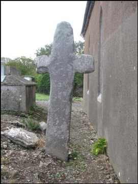
This cross [left] stands behind the church at Killiney and very close to the south wall of the building. The cross has no ring and no decoration.
Saint Enna founded a monastery here in the 7th century. (http://www.earlychristianireland.org/kerry/kerry_killiney.shtml)
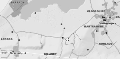
Getting There: See the Road Atlas page 56, first column, second row. Located between Castlegregory and Stradbally north of the N86 on a minor road. The cross is located behind a church building.
The map is cropped from the Historic Environment Viewer.
Kilmalkedar (Cill Maoilceadair) :
It is said the monastery at Kilmalkedar was founded by Saint Maolcethair, son of the King of Ulster, who died there in 636. He chose the site because it is near Mount Brandon, a pre-Christian religious symbol. The pilgrim’s track leading to Mount Brandon passes through Kilmalkedar.
The early monastery was established about 600. It became famous for its school during the early medieval period. (sunbright57)
Also present on the site are the collapsed St. Brendan’s oratory, a 12th century church, a stone with Latin letters known as the Alphabet Stone, an Ogham stone and a Sundial.
The Kilmalkedar site is located on the Dingle Peninsula near Murreagh on the R559. It is signposted. In the area there are numerous early Christian sites that date from the 5th to the 8th centuries. http://www.nd.edu/~archire/sites2005/KilmalkedarMonastery2.html)
The Sandstone cross, pictured above is 8 feet 2 inches (2.5m) tall. The only decoration is a raised square in the center of the crossing and a smaller square at the center. (Harbison 1992, p 130) It is unusual, though similar to the Reenconnell cross described below, in that the arms extend from the shaft about midway from the base to the top of the cross.
The Small cross, pictured to the right is near the Sandstone cross. It is rough cut cross that has no carving. The arm seen to the left in the photo has been broken. The cross may or may not be early.
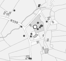
Getting There: See the Road Atlas page 55 third column, third row. Located on the Dingle Peninsula near Murreagh and along the R559. The map is cropped from the Historic Environment Viewer.
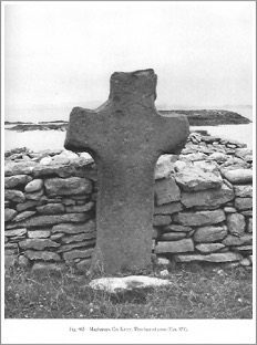
Magharees Islands:
The Site and the Saint:
An early ecclesiastical site is located on Illuantannig, the largest of the Magharees Islands. The monastery was reputedly founded by St. Senach. According to Catholic Online Senach was born in 488 near Kilrush in County Clare. It has been suggested that his name in the old Gaelic means “ little old wise man. He is presumed to have died on Scattery Island in 544. The monastery there was one of several he founded during his career. (catholic.org/St.Senan) There are two oratories, three beehive huts, and three stone slabs in addition to the cross within the monastic enclosure.
The Cross
A large cross, 5 feet 11 inches (1.82m) tall, stands beside the middle leacht in the enclosure. The cross is undecorated. Small holes at the crossing indicate there was once a plaque attached to the cross. (Cuppage, p. 295) Harbison adds that the cross measures 41inches (1.05m) across the arms and is 4+ inches (11cm) thick. He also notes that rough areas on the shaft and arms suggest the possible presence of a ring. (Harbison, 1992, p. 138; photo above Vol. 2, Fig. 465)
Getting There: See the Road Atlas page 56, 1 1. Located on an island north of Rough Point. It will take a boat to reach the island, and there is no landing place.
The map is cropped from the Historic Environment Viewer
Reenconnell (Rinn Chonaill):
The Site and the Saint
There does not seem to be any information on the history of the Reenconnell site. Lochlann NcGill, in his book In Conall’s Footsteps, suggests that the site likely takes its name from St. Conall and may be the “most southerly extension of the cult of St. Conall.” (McGill, p. 110) The St. Conall named here appears to be St. Conall of Iniscaoil who is associated with County Donegal. He is associated with the island of Inishkeel where there also a monastery and a High Cross. (http://omniumsanctorumhiberniae.blogspot.com/2013/05/saint-conall-of-iniscaoil-may-20.html)
The Cross
An incised cross and two concentric circles representing the ring on the west face. (Harbison 1992, p 162)
Reenconnell is near Kilmalkedar, Reask and the oratory of Gallarus. This cross is said to be in the location of an ancient cemetery. Little else is known of the history of the site and the cross is all that survives.
Finding Reenconnell was interesting. Peter Harbison describes it as standing in the second field in from the road. The National Monument Service provides a map that got us very close. Neighbors in the area gave us the final clues. It was not, however, until I walked across the first field and entered the second that I could see the top of the cross in the distance. It is certainly not visible from the road.
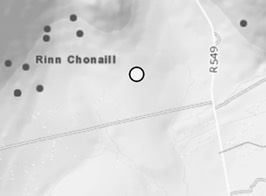
Getting There: See the Road Atlas page 55, third column, third row. Located on the Dingle Peninsula east of Murreagh. From Dingle Town take the R549 north. About five km along the road you will come to an unnamed road going west. Go west (left). The road you are looking for is just below the “dar” of Kilmalkedar on the Road Atlas. There is a short lane just before the first house along the road. The fields can be accessed from there, the cross is in the second field in from the road to the north. The map is cropped from the Historic Environment Viewer.
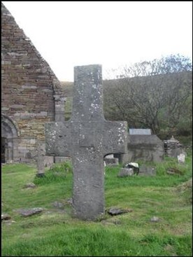
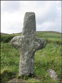
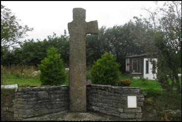
Tonaknock:
The Site:
This site has been divided by the modern road. On the west side of the road is the cross. The ruins of a church are across the street. It and the cross are the only surviving remains of what became Tonaknock Abbey. The Abbey was built for the Canon Regulars who were active in Ireland from the 12th century and beyond. It was a center of educating priests of the movement. The Abbey was in operation till about 1600. (http://www.discoverireland.ie/Arts-Culture-Heritage/killahan/50298)
The cross probably dates to the 7th-century suggesting that there was a monastery there that was either taken over or renewed by the Canon Regulars. It will be noted that Tonaknock is not one of the monasteries listed above.
The Cross:
The only decoration on this cross (see photo to the right) seems to be small incised circles on the west head and face. It is believed to date from the 9th century. Legend says the south arm was broken by a cannon ball during the Desmond insurrection in the 16th century.
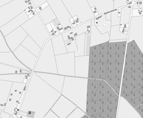
Getting There: See the Road Atlas page 57, third column, first row. Located north of Tralee and west of the R556. Pass through Abbeydorney. About three km beyond Abbeydorney take a road that angles back to the left. The cross is standing beside the road on your right less than one km from the turn. The ruin of a church is across the road from it. On the map to the left the road that runs north/south is the R556.
Other Kerry Crosses: For these crosses the descriptions and locations are taken, with one exception, directly from Crawford’s article noted above.
Blasket Islands/Inishtooskert:
Two crosses are marked on the Ordnance map and listed in the National Monuments Service website. (webgis.archaeology.ie) Cary Meehan mentions three crosses. (Meehan, p. 563) One is said to be a small plain cross, 3 feet high, and the other, the shaft of a similar one. The crosses are near the ruins of a Church and beehive huts on Inis Tualsceart in the Blasket Islands, 12 miles west of Dingle and 5 miles north of Great Blasket. John Musther reports that the island is variously referred to as Dead Man, Sleeping Giant or the Bishop, owing to its profile. He also tells us the oratory there was dedicated to St. Brendan. (http://www.earlychristianireland.net/Counties/kerry/inishtooskert/)
The image to the right can be found on numerous websites. This image was copied from imagine.com, Inishtooskert, Blasket Islands, Dingle Peninsula, County Kerry, Ireland. The cross in the foreground is the only one of the two or three for which photos could be found.
Skellig Michael:
The Site
The history of the monastery on Skellig Michael is fragmentary. It has been suggested that the monastery may have been founded as early as the 6th century, but there is no certainty about the founding date. Saint Fionán (Finan) is remembered as the founder. More on Finan below. What we know of the history of the monastery is summarized by Ann O’Sullivan and John Sheehan in their Archaeological Survey The Iveragh Peninsula. They mention the following.
- In the late 8th century the Martyrology of Tallaght mentions the death of Suibni in Scelig.
- AI824.3 “Scelec was plundered by the heathens and Étgal was carried off into captivity, and he died of hunger on their hands.” (Annals of Inisfallen)
Mervyn Archdall, writer of Monasticon Hibernicumn suggested that Etgal was a hermit who lived on the island. (Archdall p. 246)
- AI882.2 Repose of Flann son of Cellach, abbot of Scelec.
- M950.3 Blathmhac of Sgeillic died. (Annals of the Four Masters)
- M1042.3 Aedh of Sgelic-Mhichil;
It was not until the about 1044 with the death of Aedh of Scelic-Mhichil that the name is given as Skellig Michael. This appears to have been a dedication to the Archangel Michael. It was also about this time that a new church or chapel in the monastery was dedicated to Saint Michael.
In the 13th century, due in part to climatic changes that brought colder weather and more frequent and harsher storms, the inhabitants of the monastery moved to the mainland at Ballinskellig. This new site is located on Ballinskelligs Bay on the east side of the peninsula where it was protected from storms coming from the west.
The Saint:
Patrick J. Lynch, writing about St. Finan’s Church at Killemlagh (on the west coast of the Iveragh peninsula), quotes Canon O’Hanlon as saying that a St. Finan, the leper (St. Finan Cam) founded monasteries at Derrynane, Lough Currane and Skellig Michael. The four above mentioned sites are all in a relatively small area on or near the Iveragh peninsula. Killemlagh is on the west coast of the Iveragh peninsula south of Portmagee; Derrynane is located on the south side of the Iveragh peninsula south of Waterville, Lough Currane is just to the east of Waterville; and Skellig Michael is located off the west coast of the Iveragh.
While Lynch is focused on the identification of the saint related to St. Finan’s Church at Killemlagh, he lifts up the difficulty of knowing exactly who is credited with the founding of the Skellig Michael monastery. There seem to have been at least three saints with the name Finnian, Finan, Fionan who were related to monasteries in Ireland. They are Finnian of Clonard and his disciples Finan of Inisfallen on Loch-lein and Finan of Loch-Lee or Loch Currane. It is possible that more than one Finan was active in the area around the Iveragh peninsula. (Lynch, St. Finan’s Church at Killemlagh)
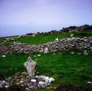
The Crosses
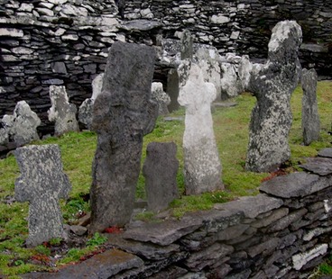
There are numerous crudely cuts stone crosses on Skellig Michael monastery. A collection of them mark the graves of brothers in what is known as the Monks Graveyard. The photo to the right shows some of these crosses that served as grave markers. Detailed information on these can be found in The Iveragh Peninsula: An Archaeological Survey of South Kerry by Ann O’Sullivan and John Sheehan.
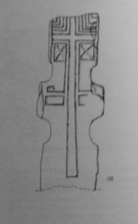
The Seven Foot Cross
"A rude cross, about 7 feet (2.1m) high, formed by 4 notches cut in the stone; it has a double-lined cross incised on it.” (Crawford, p. 207)
This cross is sometimes called the Priest’ Cross. It has a Latin cross inscribed on the stone that covers much of the SW face. Below each arm, in a frame, there is a diagonal cross. (O’Sullivan and Sheehan p. 288, illustration to the left p. 280)
"A rude cross, about 7 feet high, formed by 4 notches cut in the stone; it has a double-lined cross incised on it. At ruins of monastery on island, 16 miles southwest of Valentia.” (Crawford, p. 207)
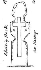
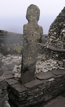
The Five Foot Cross:
"A rude cross, about 5 feet high, similar to the 7 foot cross above. Near summit of island.” (Crawford, p. 207) The cross pictured to the right below seems to be this cross.
 O’Sullivan and Sheehan describe this cross as follows: “This large stone cross, with
 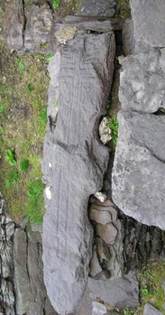 hollowed angles and slightly projecting arms, stands on leacht (13). Almost the entire length of its W face is occupied by an outline Latin cross, the open-ended arms of which extend to the sides of the stone. A series of diminishing L-shaped grooves occupy the spaces between the arms of the cross and the upper sides and top of the slab, while beneath each arm is a diagonal cross framed by a grooved rectangle. Extending down from the inner end of each rectangle is a long linear groove; that at N turns outwards sharply to form an angular volute. Beneath both examples, on the arms of the slab, are traces of grooved rectangles. H: 1.47,, W: .57, T: .06m.” (O’Sullivan, p. 288) In addition, they provide an illustration, seen to the left.
A careful examination of the cross to the right seems to match the description of the cross illustrated to the left. The dimensions seem correct as do the design features. It is was obviously not standing in 2008 as was the cross described by O’Sullivan and Sheehan in 1996. It also appears to have suffered additional damage.
As noted above, there are numerous additional stone crosses on Skellig Michael. Detailed information on these can be found in The Iveragh Peninsula: An Archaeological Survey of South Kerry by Ann O’Sullivan and John Sheehan. The photo below left shows a number of crosses and cross slabs around the Monks Graveyard.
Getting There: See the Road Atlas page 57 A 5. Tours are available from Portage (Road Atlas page 57 B 4) No map is provided.
Tonaknock, Co. Kerry: The only decoration [left] seems to be small incised circles on the west head and face. It is believed to date from the 9th century. Legend says the south arm was broken by a cannon ball during the Desmond insurrection in the 16th century.
The ruins of a 7th-century church known as Tonaknock Abbey still stand. It was a collegiate church built for the Canon Regular and included a centre for the education of its priests. It continued to operate until 1600. (Abbeydorney)
Sources Consulted:
Abbeydorney: (http://homepage.tinet.ie/~abbeydorney/book/killahan.html)
Annals of Inisfallen https://celt.ucc.ie//published/T100001A/index.html
Annals of the Four Masters, CELT, Corpus of Electronic Texts, http://www.ucc.ie/celt/publishd.html,
Bennett, Isabel, The Archaeology of County Kerry, Archaeology Ireland, Vol. 1, No. 2 (Dec., 1987) pp. 48-51
Catholic Online: catholic.org/St.Senan
Crawford, Henry S., A Descriptive List of the Early Irish Crosses, The Journal of the Royal Society of Antiquaries of Ireland, Fifth Series, Vol. 37, No. 2, [Fifth Series, Vol. 17] (Jun. 30, 1907), pp. 187-239
Discover Ireland: http://www.discoverireland.ie/Arts-Culture-Heritage/killahan/50298
Earlychristianireland:
(http://www.earlychristianireland.org/kerry/kerry_killiney.shtml)
http://www.earlychristianireland.net/Counties/kerry/inishtooskert/
Harbison, Peter; "The High Crosses of Ireland: An Iconographical and Photographic Survey", Dr. Rudolf Habelt GMBH, Bonn, 1992. Volume 1: Text, Volume 2: Photographic Survey; Volume 3: Illustrations of Comparative Iconography.
Kilmalkadar Monastery: http://www.nd.edu/~archire/sites2005/KilmalkedarMonastery2.html)
List of Monastic Houses in County Kerry: https://en.wikipedia.org/wiki/List_of_monastic_houses_in_County_Kerry
Lynch, Patrick J., St. Finan’s Church at Killemlagh, The Journal of the Royal Society of Antiquaries of Ireland, Vol. XXXII. Consecutive Series, Vol. XII - Fifth Series, University Press, Dublin, 1902.
Meehan, Cary, "The Traveller’s Guide to Sacred Ireland", Gothic Image Publications, Gastonbury, Somerset, England, 2002.
National Monument Service: webgis.archaeology.ie
O’Sullivan, Ann and Sheehan, John, The Iveragh Peninsula: An Archaeological Survey of South Kerry, Cork University Press, 1996.
Rootsweb: https://sites.rootsweb.com/~irlkik/ihm/
Sunbright57, “Kilmalkedar Monastic Site, Dingle Peninsula, Co. Kerry, Southern Ireland”, The Journal of Antiquities, http://thejournalofantiquities.com/2015/05/05/kilmalkedar-monastic-site-dingle-peninsula-co-kerry-southern-ireland/
World Heritage Ireland: http://www.worldheritageireland.ie/skellig-michael/historical-background/